31 December 2002: El Calafate, Argentina
Subject: Argentina
Ushuaia
Ushuaia, the world's most southerly town. Well, if you ignore Puerto Williams, over the Beagle Channel on Chillean Isla Navarinos, it is (and the Argentines do). Though actually it isn't as far South as plenty of places in Europe are North (someone look it up for me). Basically it's a town of about 40,000 people with some big mountains behind and the Beagle Channel in front. The rest of the Gran Isla Del Tierra Del Fuego is flat, just like the Falklands (those of you my age or older will remember exactly what the terrain of the Falklands is like), but the area around Ushuaia is more mountainous. The highest point, Monte Veronica, is about 1300m, with most of the other peaks around the 1000m mark or a bit more. To the West in the Chillean part there are some much bigger peaks with big glaciers and snowfields, but it is hard to see them from the Argentine side or the border and harder to visit them.
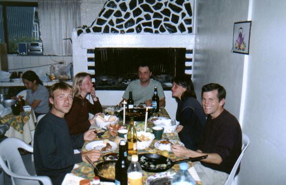
I arrived with Karina from Belgium and we stayed in a hostel that turned out to be Ushuaia's Israeli hangout. (For some reason, Israelis tend to congrugate much more than other nationalities.) This made Christmas quite interesting! The non-israelies amongst us cooked ourselves a nice meal on Christmas Eve, accompanied by a few bottles of cheap but pleasant Argentine wine, and at midnight the lady who ran the place produced some drinks and nibbles. But before we could tuck in she wanted to read an appropriate bible extract - and as the only native English speaker I was volunteered to read the English translation! For some reason the Gideons like the King James Version, so I don't think the assorted French, Belgian, Israelis and others understood much of it. Here we all are:

We did a couple of day walks from Ushuaia, one up to the glacier behind the town in what is in winter the ski resort. We got to walk up some snow and saw a nice view and had tea and cakes in a swiss-style tea chalet afterwards. (Argentina is if anything even more like a European country than Chile, yet since their recent currency devaluation the prices are bargains. Only films and stamps are more expensive than in Chile.) Then we went for a walk around the Parque National Tierra Del Fuego, which has some lovely coastal and woodland walks (though it was raining which didn't help). I have taken lots of pictures of the flowers, and one of the sign at the end of the road - it is the end of the Panamerican Highway and says "Alaska 17,384km".
At about that point we discovered that getting out of Ushuaia would be more difficult than getting in had been. It looked like all of the buses and planes were fully booked for weeks! But a friendly travel agent got us seats on a plane only a couple of days later, and we decided to spend them on a short trek near the coast. The idea was to set off Eastwards from Ushuaia and walk along the coast path to a river, and to follow the river inland and over a pass to meet the main road, from where we could hitch-hike the short distance back to the town.
The first bit along the coast went very well; there were nice views of the Beagle Channel and interesting vegetation. There is lots of Firebush, a shrub with bright red flowers. (I have bought a field guide to Patagonia including plants, birds, trees and so on, so for once I have a clue what I am looking at!) Then we reached the river and started inland, but we had a few problems. Most seriously we didn't have a map. I had had a good look at one stuck on the wall in Ushuaia's Club Andino, but it is impossible to buy them as, apparently, the government can't afford to buy the ink to print them with. (Do you believe that?) Anyway we lost the path and ended up following a side-stream rather than the main river and spent the night camped in a clearing in the wrong place.
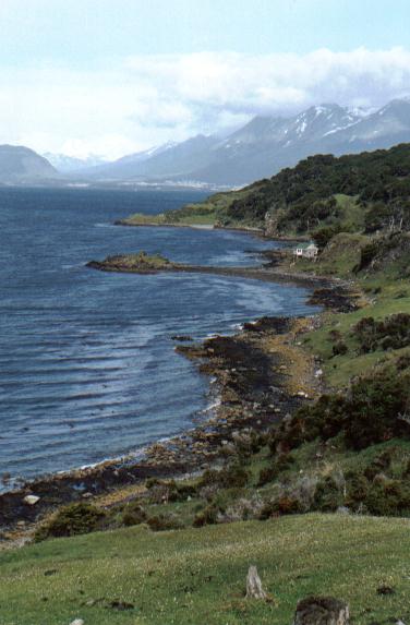
But at least thanks to stelite navigation we knew what we'd done wrong and the following morning we set off in the right direction and eventually even found the path again. But the depressingly truthful satelites were telling us that we were doing less than a kilometer per hour and it didn't increase on the path as there were lots of really muddy patches where it had been churned up by cows. So at three in the afternoon, less than four kilometers from the coast, we turned back. But it had been an enjoyable trip despite not achieving our goal. Here is a view looking back towards Ushuaia along the Beagle Channel coast:

So this afternoon we flew from Ushuaia Malvinas Argentinas Internationl Airport to El Calafate, a rather smaller town back on the mainland and not far from Los Glaciares national park. Keep tuned for further developments.