31 December 2002: El Calafate, Argentina
Ushuaia
Ushuaia, the world's most southerly town. Well, if you ignore
Puerto Williams, over the Beagle Channel on Chillean Isla Navarinos, it
is (and the Argentines do). Though actually it isn't as far South
as plenty of places in Europe are North (someone look it up for me).
Basically it's a town of about 40,000 people with some big mountains
behind and the Beagle Channel in front. The rest of the Gran Isla
Del Tierra Del Fuego is flat, just like the Falklands (those of you
my age or older will remember exactly what the terrain of the Falklands
is like), but the area around Ushuaia is more mountainous. The
highest point, Monte Veronica, is about 1300m, with most of the other
peaks around the 1000m mark or a bit more. To the West in the
Chillean part there are some much bigger peaks with big glaciers and
snowfields, but it is hard to see them from the Argentine side or the
border and harder to visit them.
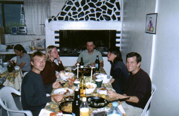
I arrived with Karina from Belgium and we stayed in a hostel that
turned out to be Ushuaia's Israeli hangout. (For some reason, Israelis
tend to congrugate much more than other nationalities.) This made
Christmas quite interesting! The non-israelies amongst us cooked ourselves
a nice meal on Christmas Eve, accompanied by a few bottles of cheap but
pleasant Argentine wine, and at midnight the lady who ran the place
produced some drinks and nibbles. But before we could tuck in she
wanted to read an appropriate bible extract - and as the only native
English speaker I was volunteered to read the English translation!
For some reason the Gideons like the King James Version, so I don't
think the assorted French, Belgian, Israelis and others understood much
of it. Here we all are:
We did a couple of day walks from Ushuaia, one up to the glacier
behind the town in what is in winter the ski resort. We got to walk up
some snow and saw a nice view and had tea and cakes in a swiss-style
tea chalet afterwards. (Argentina is if anything even more like a
European country than Chile, yet since their recent currency devaluation
the prices are bargains. Only films and stamps are more expensive than
in Chile.) Then we went for a walk around the Parque National Tierra Del
Fuego, which has some lovely coastal and woodland walks (though it was
raining which didn't help). I have taken lots of pictures of the flowers,
and one of the sign at the end of the road - it is the end of the
Panamerican Highway and says "Alaska 17,384km".
At about that point we discovered that getting out of Ushuaia
would be more difficult than getting in had been. It looked like all of
the buses and planes were fully booked for weeks! But a friendly travel
agent got us seats on a plane only a couple of days later, and we decided
to spend them on a short trek near the coast. The idea was to set off
Eastwards from Ushuaia and walk along the coast path to a river, and to
follow the river inland and over a pass to meet the main road, from
where we could hitch-hike the short distance back to the town.
The first bit along the coast went very well; there were nice views
of the Beagle Channel and interesting vegetation. There is lots of
Firebush, a shrub with bright red flowers. (I have bought a field guide to
Patagonia including plants, birds, trees and so on, so for once I have
a clue what I am looking at!) Then we reached the river and started inland,
but we had a few problems. Most seriously we didn't have a map. I had
had a good look at one stuck on the wall in Ushuaia's Club Andino, but it
is impossible to buy them as, apparently, the government can't afford to
buy the ink to print them with. (Do you believe that?) Anyway we lost
the path and ended up following a side-stream rather than the main river and
spent the night camped in a clearing in the wrong place.
But at least thanks to stelite navigation we knew what we'd done wrong
and the following morning we set off in the right direction and eventually
even found the path again. But the depressingly truthful satelites were
telling us that we were doing less than a kilometer per hour and it didn't
increase on the path as there were lots of really muddy patches where it had
been churned up by cows. So at three in the afternoon, less than four
kilometers from the coast, we turned back. But it had been an enjoyable
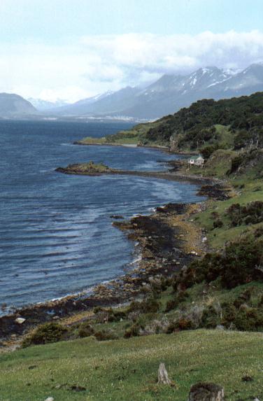
trip despite not achieving our goal. Here is a view looking back towards
Ushuaia along the Beagle Channel coast:
So this afternoon we flew from Ushuaia Malvinas Argentinas Internationl
Airport to El Calafate, a rather smaller town back on the mainland and not
far from Los Glaciares national park. Keep tuned for further developments.
10 January 2003: El Calafate, Argentina
Wow! The last few days have been some of the best of the trip so far.
Maybe even the best of all. First a day trip to the spectacular Perito
Moreno glaciar, and then six days hiking near Monte Fitz Roy and Cerro
Torre, two of the world's most spectacular mountains. My photos are being
developed as I write this but there doesn't seem to be a scanner in this
town, so you'll have to wait a bit for the photos.
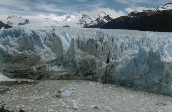
Perito Moreno
For some reason, unlike just about every other glacier in the world,
this one is actually growing. It flows down from the Campo De Hielo Sur,
a huge ice cap amongst the high mountains on the Argentine/Chilean border,
into Lago Argentina, a vast glacial-green lake with its head in the
mountains and its body spread out over the flat semi-desert that they
rise from. The lake it quite narrow where it joins, and every few years
during the twentieth century the glaciar would actually reach the far side
of the lake, blocking the flow of water. The water would back up until
eventually the ice dam broke under the pressure. It would take just a
couple of days for the thirty metres of excess water to return to
normal.
You don't get to see anything quite that dramatic on the regular
tourist excursions, but it is certainly a spectacular sight. The glaciar
is actually touching the bank, but there is a tunnel through it through
which the lake water flows. It is supposed to be advancing at three
metres per day, and that means a lot of ice falling into the lake. Basically
the trip involves watching bits flake off and fall into the water, 70m
below. We were lucky to have excellent weather while we were there and
watching the ice falling, and just looking at the extraordinary form of the
glaciar surface, was delightful. Thoroughly recommended to anyone who
happens to be passing.
El Chaltén
For "ordinary" tourists the Perito Moreno is the highlight of the
Los Glaciares national park. But for those with the energy to hike for
a few hours the spectacular mountains of the Fitz Roy area are the best
bits. Karina and I took a bus from the comparative metropolis of El Calafate
to El Chaltén, a tiny place constantly sandblasted by wind coming down from
the ice cap. The journey itself was a fantastic experience; about 300km
on unsurfaced roads through spectacular landscapes with incredible views.
The route first goes east into the flat desert, which looks great at this
time of year with lots of tufty clumps of brightly coloured vegetation
fluttering in the wind. Then it turns through almost 180 degrees to return
to the mountains a little further north, and as you drive along you can see
the famously sheer-sided summits of the Monte Fitz Roy and Cerro Torre
groups and the edge of the Campo De Hielo behind them. We got to El
Chaltén after dark, and it really has the feeling of a last outpost of
civilisation. (Like El Calafate, it is not really connected to the
outside world; it has its own small power station on the main street, for
example!)
The next day, having stocked up on provisions in a tiny supermarket,
we eventually set off into the hills at half past four in the afternoon!
But luckily aorund here it gets dark very late, so we still had plenty of
time to walk up to the free campsite, put up the tent, and do an evening
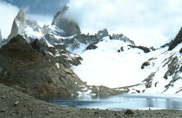
trip to see a view of the mountain. It was spectacular! Fitz Roy is
almost 3500m high and we were still not too much about sea level. The
top thousand metres are vertical rock, and below that the snow tumbles down
steep glaciers. Out viewpoint was at the outlet from a lake;
the glaciers stopped about 300m
above the lake, and from time to time lumps of ice would fall off and rumble
down the rock into the water.
The next day we walked up to another, higher, viewpoint; a semi-frozen
lake with, again, Fitz Roy towering behind. Unsatisfied with the relatively
unadventurous walk to get there we set off around the lake and up towards
a small summit; the route was steep and rocky but I managed to get to the
terrifyingly small and precipitous top, from where I could see down onto
the previous day's lake and glacier and around at Fitz Roy and all its
subsidary summits. This area is notorious for bad weather, with groups
of climbers egularly spending weeks at base camp waiting for the wind to
drop, so we were really lucky to get great views from just about everywhere
we went.
Continuing what was to become a daily pattern, having got down from
this viewpoint we set off on the second walk of the day, down the valley and
around the corner into the Valle Electrico. We were hoping to climb up to
another high vantage point here, but after a windy night the next day had to
sort of wind that really could blow you off your feet. So instead we did a
shorter walk up to the lake at the top of the valley, trying to decide on
the way whether it was raining or if the water was being picked up from the
lake by the wind! But as this was the only really windy day we're not
complaining.
We spent the afternoon walking to our next campsite at Lago Capri; we
had to retrace our steps for a while which is never that enjoyable, but the
campsite made up for it when we got there. It is a small, free campsite
overlooking a lake in which Monte Fitz Roy is reflected. We pitched the
tent so that we could open the door and see the view at first light.
The next day was probably the easiest walk of the trip; we continued
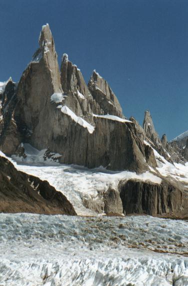
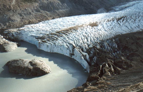
southwards to the next valley where a huge glacier flows fown from Cerro Torre
and the back of Fitz Roy, ending in a lake.
Cerro Torre is an astonishingly
tall and thin needle of rock, capped by an overhanging mushroom of snow. It
was considered unclimbable until an Italian said he had done it using a
pneumatic drill. But many people don't believe him, especially as the
line of drill holes comes to an abrupt stop well short of the top.
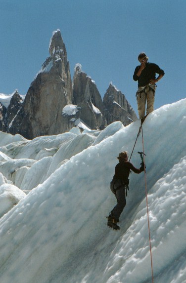
Anyway, we camped here and the following day joined an organised group on
a trip onto the ice. There were only three of us with two guides - not
bad as the other groups seemed to be huge and had paid the same price.
(The company is called Viviendo Montaña if anyone is interested.) After
a tyrollean traverse to get over the river and a walk above the edge of the
lake we got onto the ice and put on our crampons. (MUHC people will be
impressed to know how well our fellow client got on with a pair of Camp
Jollies strapped to his trainers!) We strolled around for a few hours,
looking down holes in the ice and had a go at climbing a bit of ice.
All the time there were spectacular views of the mountains and they
feature as the backdrop of most of my photos. Here is Karina getting to
the steep bit of the ice climb as our guide looks on:
By this time our food ration, which had already been augmented with
a meal from our glacier excursion company, was running low and it was time
to return to El Chaltén. The next day, as a change from walking with
huge rucksacks full of camping gear, we did a day walk. The maps show a
path to a 1270m top that ought to have views of all the mountains, but we
got there and decided that it would be better from a bit further along
the ridge. We finally got to a point at about 1550m with a fabulous
panorama of just about everything in the area. Nothing beats views from
summits - looking down, rather than up, on things, and having a 360
degree view, makes such a difference. This was a great way to end the
trip, and we got the bus back to El Calafate.
So now I am preparing to visit Torres Del Paine, and Karina is going
the other way, north through Argentina. Now it's time to collect my
photos.
14 January 2003: Puerto Natales, Chile
New Photos
I have just scanned in ten new photos from the last few weeks in
Chile and Argentina. Do check them out; most of them are on the Argentina
page, but don't miss the pair of Magellan penguins at the end of the Chile
section.
Flora
I've taken quite a few pictures of the flowers in Argentina as there
are lots of them and most of them are very pretty. And, unlike so many
of the countries that I've visited, here it has been possible to buy
books that tell you what you're looking at! Here are just a couple of
photos.
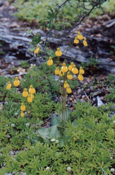
This is Topa Topa, an orchid that is found all over the place but
most conspicuously as a woodland floor plant. It would be an exageration
to say that they are as common as bluebells are in English woods, but
not much of one! They are yellow with a "lady's slipper" flower shape.
And this is the Magellan Orchid, which is probably quite rare. We
were lucky enough to find this one while we had temporarily lost the
path! It has extraordinary green veins on the petals.
24 January 2003: Puerto Montt, Chile
Final Photo
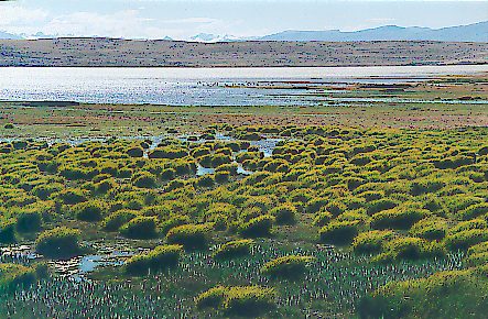
One final picture from Argentina. On my last day before getting the
bus over to Chile, Kartina and I did a walk around a lagoon with various
interesting birdlife and along the shore of Lago Argentina. This is a view
near the lagoon, and it just starts to illustrate the colours of the
vegetation in the area: clumps of quite brightly coloured stuff, waving
gently in the wind.
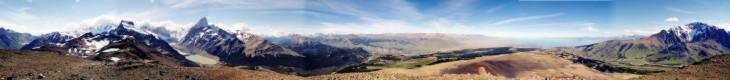
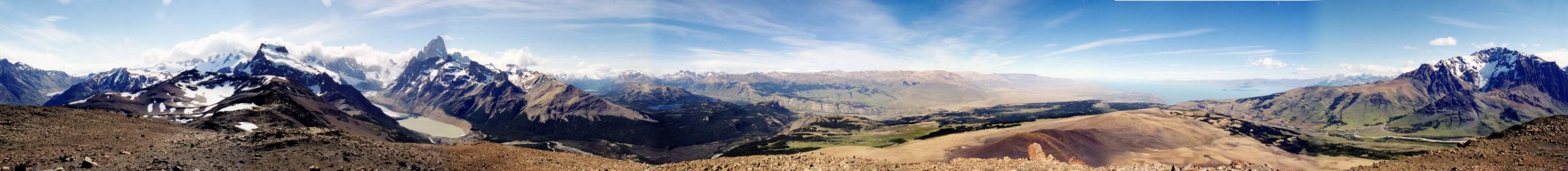
22 February 2003: Avarua, Rarotonga, Cook Islands
New Picture
My parcel of photos and books from Patagonia has found its way to
remotest Dorset and Dad has kindly scanned in and stiched together
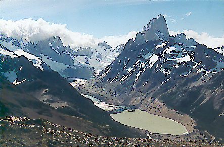
this panorama. It's from the top of the 1550m peak that Karina and I
bagged on our last day in El Chalten. From left to right, the view
is: Lago Toro, Cerro Solo, the Torre Glacier and Lago Torre (the very
tip of Cerro Torre can just about be seen above the glacier),
Monte Fitzroy, Lago Capri (dark blue, midground), and finally the
huge Lago Viedma (if I have remembered that correctly).
To see a higher-resolution version, click:
http://chezphil.org/rtw/images/ChaltenHR.jpeg
(If your browser shows you something only as wide as your screen, try
clicking on the image and see if an icon that might mean "enlarge" appears;
if it does, click on it and you'll see the full-size version).
