Peru
21 October 2002: Lima, Peru
Greetings from Peru. We've been her for four days and have explored
the city a bit and today ventured out into the countryside. Here's the
story so far.
Lima
I was preparing myself for a place like Mexico City, but actually
Lima seems much quieter and more pleasant. On our first morning we made
our way into the center (we are staying in the posh suburb of Miraflores)
and within minutes had met lots of friendly people wanting to practice
their English on us, including a tourism studies student and a big group
of schoolchildren (and it wasn't a scam). Then we did a tour of the
Cathedral, which was great. Lima was flattened by an earthquake in 1746
and they say it hasn't regained its previous grandeur, and the cathedral
building is not extra-special, but it does contain some lovely
chapels. But the highlight is the museum, containing Peruvian religious
paintings in a style that features the most extraordinary frames. One
actually had glazed compartments full of dried flowers in the frame! Then
their were some lovely nativities; they start out like big chests, and
open out to reveal all the usual Christmas characters, with the odd
llama thrown in for good luck, and in one case the Garden of Eden too!
We've been to a couple of the archaeological museums, and they do
have some lovely things: the pre-columbian ceramics are wonderful. Then
there are the textiles, which are of course of special interest to
Christine who has done dying, spinning and weaving herself. They have
some great and very well preserved pieces, including some with
brightly-coloured feathers woven in. One of the pre-Inca cultures
made the most extraordinary three-dimensional scenes with woven dolls
doing day-to-day activities, such as weaving.
Of course there are lots of modern-day handicrafts to look at too, and
we have spent more than a while in the craft shops...
Guinea Pigs in Lunahuana
Our time in Lima has been greatly enhanced by my friend Louise, who
has been here for some time working - mostly voluntairly - for various
development and human-rights groups. Her first job here was related to
guinea pig farming; they were helping small farmers to develop their
back-yard-scale guinea pig farms. So today she suggested that we should
escape from Lima and see the countryside, near the guinea pig farming
town of Lunahuana.
So four of us - Christine and I, Louise and her English friend Charlie
got up early this morning for the trip.
Getting there involves a 150km coach jorney South down the coast to
Canete, a minibus across town, then about 60km inland in a collective taxi.
The scenery down the coast is very dry; inland it is a stone desert,
mostly round water-washed pebbles, suggesting an uplifted seabed. The
sea looks to be gently-shelving with waves breaking quite a long way out,
just like the surfers like them. And at one point I saw quite a big
natural arch. Heading inland it is mostly still dry, with very bare
hillsides, but there is a reasonable-sized river (in which we dipped our
feet) and the valley bottom is cultivated.
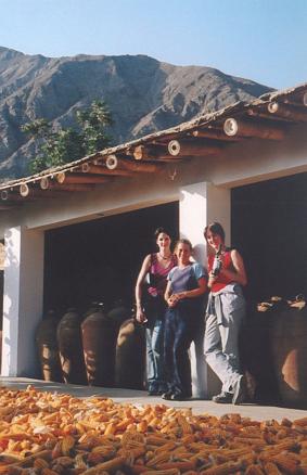
So we stopped for lunch at one of the places where Louise's group
had been involved. They had started from next-to-nothing - the man
had been slightly injured and was not up to hard-graft farming any more -
and were now breeding guinea pigs and rabbits for meat and also to sell
as breeding stock. Then his wife runs a restraunt and caters for
parties of up to two hundred guinea pig eaters! So the four of us
were no trouble. And yes, guinea pig is very tasty. Its main problem
is that it has lots of small bones that make eating it rather tedious.
But apparently it is very nutritious, so that's yet another benefit
that the community gets from the enterprise.
One of the crops they grow in the valley is Medler Fruit -
if we have the right translation - and we
got a plate of them for desert. I've never seen them before - they are
the size of a small apricot and have white flesh, a bit like a
lychee I suppose, around two or three seeds. Delicious. They also
grow grapes, and after lunch we visited a local winery where they
make wine and also distill it to make some rather nice fortified wines
(and some less lovely ones). They were storing them in some
remarkably rustic looking vessels that you would think were roman
amphoras if you saw them in a museum!
A lovely day out - though
it's a shame you have to go such a long way to get to somewhere nice.
So now we have to decide what to do next: probably a trip northwards
to Huaraz, from where we should be able to see some mountains!
25 October 2002: Huaraz, Peru
Unreset in Huaraz
We've had an interesting few days here in Huaraz - there has been
a bit of a civil war going on, though it doesn't seem to have been noticed
by the rest of Peru let alone the world.
We came here on the overnight bus from Lima. When we got here
it didn't seem odd that everything was shut: it was six in the morning
after all. But it slowly became apparent that our bus was the last one
to make it in to town before the roads were barracaded.
There are several huge mines outside Huaraz,
and it seems that the people
here think they should get more government spending because of them. I'm
not particularly sympathetic: why should a town somewhere else have
less good schools just because it isn't built on mineral-rich rocks?
Anyway, various groups including the peasants from the surrounding
countryside and the local students have been taking it in turns to
cause trouble. This isn't the first time they've done it.
For two days the roads were blocked with stones,
burning tyres and a few freshly-dead dogs to make it
extra-unpleasant. A few shop windows got broken, encouraging the
others to stay shut and put up pro-protestor placards. (We did just
about manage to find something to eat.)
I have seen no mention of this in the Peruvian press. They are
totally obsessed with their president's illegitimate daughter, and have
reported virtually nothing else since we've been here.
Anyway, there are supposed to be some lovely mountains nearby, but
we have seen nothing of them so far. If these people don't like the mine,
they had better start making the place a bit more attractive to tourists,
since that must be their second most likely source of money. They
can't expect many people to turn up if they keep this up.
Things have started to get a bit more normal today, so hopefully
we'll be able to get out and actually do something soon. If we can get up
into the mountains with a tent it doesn't matter what's
going on down here.
30 October 2002: Huaraz, Peru
Well we're back from a couple of nights camping in the
Cordillera Blanca, and Huaraz seems to have recovered from the
disturbances of a few days ago. In a couple of hours we'll be
getting on the overnight bus back to Lima, and so now I have
some time to write up what we've been doing.
More about Lima
I didn't write much about Lima before as the Guinea Pig trip
took up most of my report. But you must hear all about the
craft markets, since we spent more time there than anywhere else,
and how Lima is like Bournemouth.
¡Lima is like Bournemouth! ¿How can that be? Well for a
start they are
both on the coast and have long beaches where it is too cold for
anyone to swim without a wetsuit. But the similarities became
totally clear when we took a walk along the beach to the peir.
First we walked down from the cliff top to the beach - and this
is why I compare it with Bournemouth rather than Brighton or
Bognor, since Bournemouth has cliffs with walks down little
valleys (they call them chines) to the sea. Then there's the
peir, and the peir in Lima (or more acurately Miraflores, the
nice suburb where we were staying) is like you might hope
an English seaside peir would be: a well-preserved Art Deco
structure containing some nice boutiques and a restraunt where
you can drink a cup of coffee while watching the seagulls.
Of course real English peirs are basically amusement arcades:
so is Lima more like Bournemouth than Bournemouth itself?
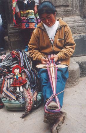
Miraflores has a whole street full of craft markets:
probably about eight places, each with dozens of stalls selling
things from around the country: knitware, rugs, paintings,
bags and lots of other goodies. Sadly a few of them had
rather dodgy items like dead bats in picture frames and things
made of feathers that responsible tourists will steer clear
of. But we spent most of three days looking around and making
a few purchases. We will be the Peruvian post office's biggest
customers when we send off our things tomorrow!
The Cordillera Blanca
So finally we got out of Huaraz into the mountains. The
Cordillera Blanca is a range about 100km or so long running
North-South in Northern Peru. The towns are at about 2500m to
3500m (Huaraz is at about 3300m); smaller villages and
agriculture reach up to about 3800m. Everything above 4000m
is protected in a national park; the snow line is at about
4800m and the peaks reach over 6000m. So it's all pretty
high: even the town of Huaraz, where I am writing this,
is higher than any of the peaks I climbed in the Canadian rockies
a few months ago
or in the Pyrenees two years ago, and our campsite last night
was higher than I have ever been in the Alps. But being so
close to the equator it is still quite warm, even in a tent
at night.
Before going camping we did a couple of lower-level walks,
mostly through villages around Huaraz, to get used to the
altitude. This gave us a fascinating insight into the lives
of the people here. From a distance their houses could be
in Southern Europe thanks to their terracota-tiled rooves.
But from close up you can see that most have mud-brick walls,
often whitewashed on the side that faces the road, and in
most cases earth floors. The people are clearly poor, but
the children all have shoes and seem to go to school.
The houses are surrounded by fields of maize, peach or
apricot orchards, plots of potatos (the lovely orange-coloured
products of which we have seen in the markets),
peas and other crops, and
eucalyptus coppice. In some places they were growing crops of
carnations, but a quite English-looking selection of garden flowers
could be found around some of the houses. Pigs, sheep, goats,
cows and horses graze and chickens, turkeys and ducks peck (just
like Nettlecombe then).
The women are mostly
dressed in traditional costume - several brightly-coloured
skirts one on top of the other and a hat - and are normally
carrying a small child or other bundle wrapped up in a big
square of bright patterned material on their backs. The
men are less interesting to look at! We saw lots of people
at work in the fields including several people plowing their
fields using oxen. Sadly they don't seem to like having
their photos taken, so you'll have to use your imagination to
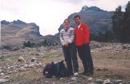
visualise the scene. Here's a picture of the two of us at
our highest point on one of these walks; behind us the gap
in the hills leads up into the proper mountains.
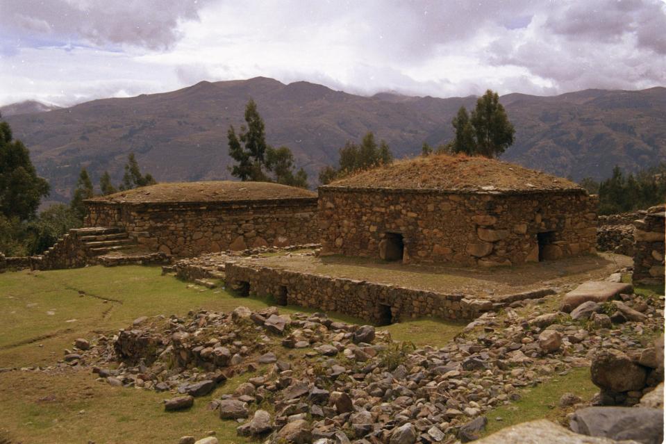
On another walk we went up to some ruins at a place
called Wilkiwaman (err, need to check that!). Actually we
got a bus up and walked back down to Huaraz after looking
around. These odd multi-storey temples are pre-inca and
remarkably well preserved.
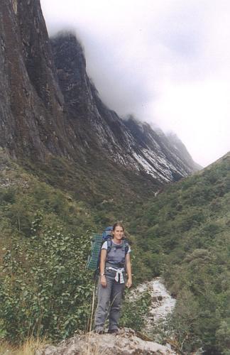
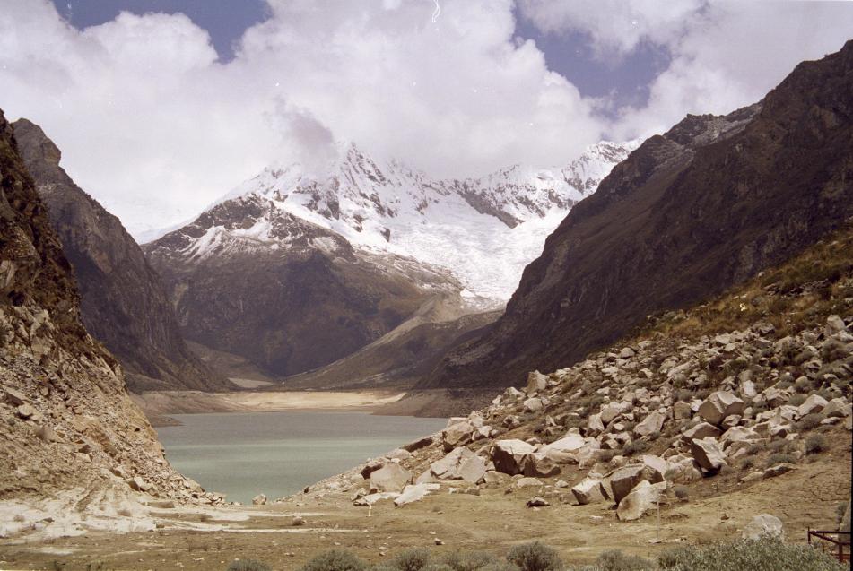
So having prepared ourselves we set off for three days
and two nights at Laguna Paron. The idea was to walk up from
the village at about 3000m through a gorge to the Laguna at
4200m, do some walks from there to see the surrounding
big peaks, and then descend the same way. Here's Christine
shortly after we set off:
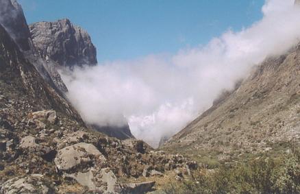
Here's a view looking down the gorge. When we were there
I tried to think of some other mountain area to compare it with,
and I think the cliffs are about the same size as those in
Glencoe, though the gorge is narrower, and the sides are steeper
and less vegetated.
Unfortunately it didn't work out quite as planned. The
walk up the gorge - a good kilometer vertically in about 10km
horizontally - took most of two days, and once we got to the
top Christine got ill (a dodgy salad she thinks). So we
didn't get to see much of a view. This is about as much
as we saw: Laguna Paron and a hint of some big snowy things
in the distance:
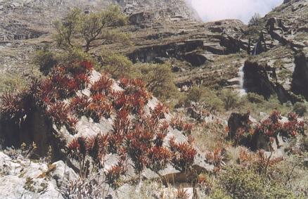
Here are a few photos of the vegetation. In Costa Rica
we got very used to Bromeliads growing all over the trees, but
here they grow on rocks too!
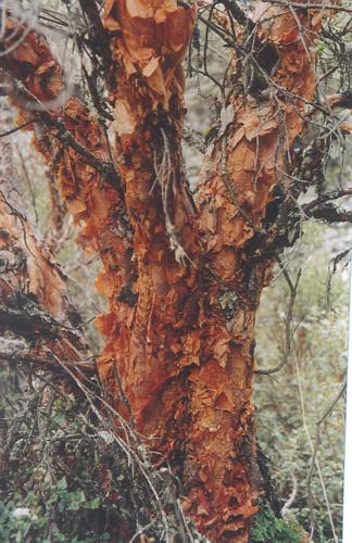
Many of the trees had this lovely paper bark:
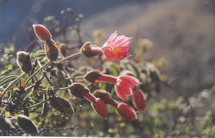
There were flowers too, including this flowering creeper
that Christine says looks like a passion flower:
Anyway, now we're going back to Lima and on Thursday we'll
be flying to Cusco. Watch this space for more news!
3 November 2002: Cusco, Peru
New Pictures
I've scanned in a lot of new photos, including a few frogs
from Costa Rica, pictures from our trip to the Cordillera Blanca,
and the following ones from here in Cusco.
You'll have to go to the Costa Rica and Peru pages to see them all.
Cusco
I don't think Cusco needs much introduction: capital city of the
Inca empire, bashed about rather by the Conquistadors, and still full
of history both pre- and post-conquest. You really can find Inca
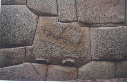
stonework like this right in the middle of the city:
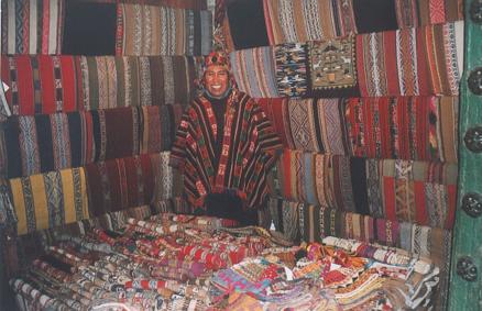
As well as all of the history it is full of spending opportunities,
and the faces of people like this light up when they see Christine coming:
8 November 2002: Cusco, Peru
Cusco
Well we've been in Cusco for about a week and have visited
most of the attractions in the city and the immediate vicinity.
And I can think of no better adjective than "Rubbish"! Cusco calls
itself the "Cultural Capital of Humanity", or some such hyperbole,
but frankly places like Bridport or a tiny village in Cambridgeshire
whose name I can't remember are better at organising a museum.
Here it is normal to find display cases with not a single label.
For example, in the Museum of Religious Art there is a pair of rooms
containing about a dozen panels of a huge mural painting - recognisably
set in Cusco, but without a single word of explanation. Then in
another museum they had a room with about four very exotic cloaks,
with lots of gold threads and other finery. They could be part of
a bishop's regalia, but with not a single word of explanation (in any
language) how are we supposed to know? (And these things were held
in place in their cases with huge great nails right through the fabric!).
Actually the post-conquest art is more impressive than the Inca
stuff, since all of the nice Inca stuff was destroyed and melted down
by the Conquistadors. But some records do exist and I'm surprised that
there has been no attempt at describing it. The religious center of
Inca Cusco was a complex containing temples of the Sun and Moon, the
sun temple being plastered in gold and arranged so that sunlight would
reflect off everything. Similarly the moon temple was covered in silver.
Outside they had fields of maize made from gold and silver. The
conquistadors took all the precious metals and eventually built a
convent over the ruins. But in 1950 an earthquake partially destroyed
the convent, leaving much of the Inca stonework visible. You can now
visit this - but there is simply no effort to describe what it might
once have been like, or to even tell any of the history. Worse than
that the Inca rooms have labels that are essentially made up, such as
"Sacrifice Room" - a lump of post-conquest carved stone is placed in
the middle of the room to give the impression of an altar.
I'm afraid I don't have any photos of the ghastly places to scan
for you: all of the museums ban photography. But they then they
don't sell any postcards or guidebooks, so no-one has any record of
their visit. Probably best to forget it as quickly as possible.
One day we went out to Chinchero, a village about an hour away
with a craft market [you can imagine the glint in Christine's eyes]
and some ruins. The ruins were quite impressive - lots of
agricultural terraces still being used to grow potatos, and some
buildings on the top. But not a word of explanation of course. Then
where the temple had been there was a church of rather rustic
construction. Despite - or perhaps because of - its rustic
architecture it was most splendidly decorated inside: lots of
fabulous wall and ceiling paintings. But of course you can't buy
any souvenir postcards or take any pictures...
There are various archaeological sites just outside Cusco that
are easy to visit, but not one of them has a single word of explanation
anywhere. (The Mexicans do far better than this at their pre-conquest
sites.) Then there's the question of how much of the stonework is
original and how much is modern construction. Quite why they feel the need
to build what they think may have been on top of the remaining Inca
foundations I really don't know, but it's generally not difficult to
tell the difference between the perfect Inca stonework and the
modern, which is like a DTCV-quality dry stone wall with cement
holding it together! If they could have put just some of the effort
that has gone into this contruction work into a few information
panels it would be a much better experience.
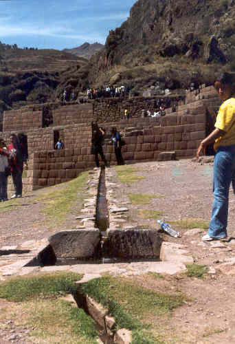
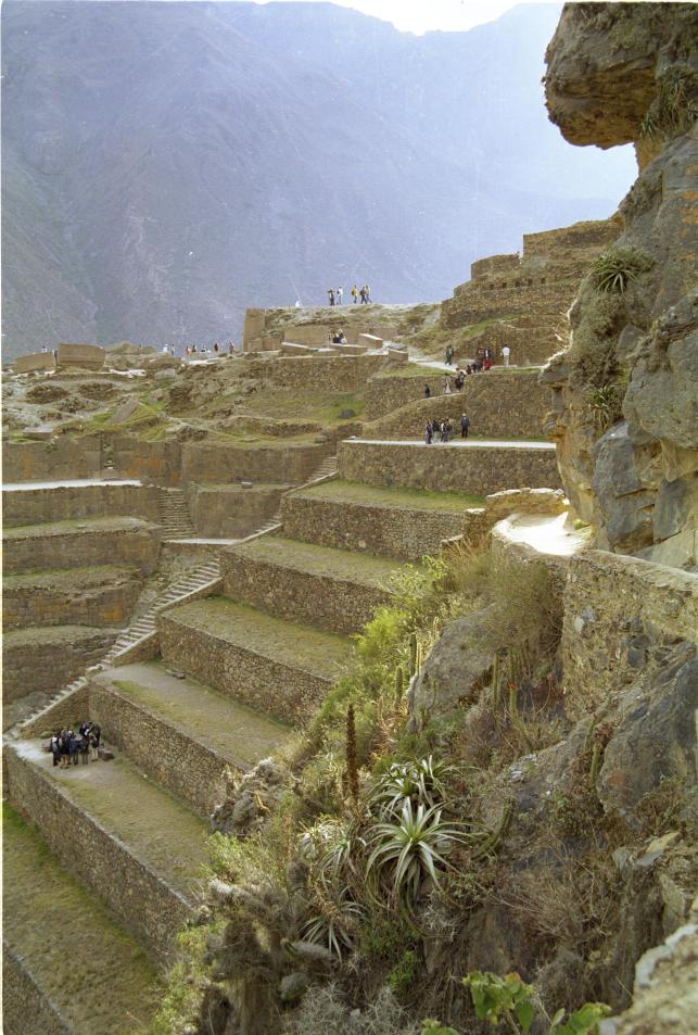
Here is a picture of part of the ruins at Pisac, north of Cusco
(and also featuring a nice craft market....). The central temple complex
has some nice stonework that you can see in the background, and the
Inca water channels, of which they were very fond, are still working.
Anyway that's enough whinging. I will try and find something
nice to say next time.
17 November 2002: Cusco, Peru
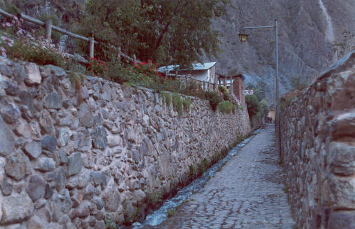
Ollantytambo
Having spent rather a long time in Cusco we had to go somewhere else,
so we took a couple of buses to Ollantytambo, on the Urubamba river.
Ollantytambo has some impressive Inca ruins above a small town which
still has its Inca street plan (the only town to do so). Below the
town, Inca agricultural terraces stretch down to the river.
Ollantytambo was the site of the Incas' penultimate stand against
the spanish. A fairly small Spanish force was defeated at the steep stone
terrace walls; apparently the Incas managed to divert the river to flood
the ground at the foot of the walls up to the horses' bellies!
If you remember a
"secrets of the ancients" TV documentary about Inca stone work, Ollantytambo
is the place where they demonstrated how they may have moved the huge
rocks from the hillside opposite, down to the valley, across the river
and up to their final position. In the town I spotted the huge "tired
stone" that had been sat in the corner of a square for a few hundred years
and which they demonstrated could be dragged quite quickly over the
cobbled road surface if you had enough people. (Of course you wouldn't
know about any of this if you hadn't seen the TV programme: there is
zero information for visitors at the site.)
The ruins themselves consist of some tall agricultural terraces with
lovely stonework, and a complex of temples and other buildings at the top.
The temples looked uncompleted, with some huge pink stone blocks carefully
fitted together but others left lying on their sides. Then there are
some granaries: two-storey buildings built into the hillside so that
grain can be tipped in at the top and removed from the bottom. Finally
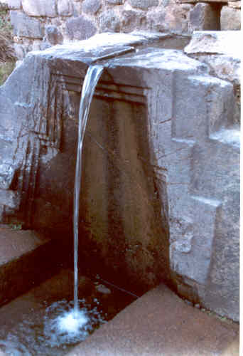
at the bottom a series of channels carved into the bedrock supply water
to some "fountains" (really waterfalls) which could have had some sort of
ritual cleansing function.
Later we walked around the town and climbed up to a vantage point
from where we could see its Inca layout. It is built on a grid
pattern with narrow lanes between high walls. The walls - built with
typically-good Inca stonework - enclose whole blocks with just a single
entrance. In many cases the tapering Inca doorways and lintels survive.
Inside the enclosures contain houses and gardens with trees and crops
such as maize. Also surviving since the Incas are water channels
running down many of the streets, reminiscent of Wells or Hobson's
Conduit in Cambridge.
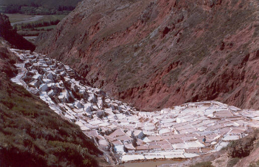
Salinas
Between Ollantytambo and Urubamba a natural salt stream emerges
from the hillside, and for hundreds or thousands of years they locals have
been filling salt pans from it. It is very photogenic. They carry the
salt away by mule.
The Inca Trail
The Incas built lots of roads and could famously send a message by
runner from Cusco to Quito more quickly than the modern Peruvian postal
service can manage it (though I hear that our first parcel full of
stuff from Lima's craft markets has made it all the way to Dorset, so
let's not be too down on them!). After the conquest, many of the roads
continued to be used and worn out, but the more difficult ones up in
the mountains that were impassable to horses and carts fell into disuse
and became overgrown.
One such trail was rediscovered by the expeditions led by Hirham
Bingham and others that uncovered Machu Pichu. But in contrast to many
of the other Inca roads it is believed by many that this trail was
actually a pilgrimage route to Machu Pichu. (Compare it with the
Christian pilgrim's roads to places like Santiago de Compostella or
Canterbury in Europe, or to Muslim, Hindu or Budhist shrines in other parts
of the world.) Today the last 40km of this trail, called "The Inca Trail",
is a popular way to get to Machu Pichu.
The popularity of the trail has resulted in lots of regulation and
paperwork. Most importantly you can now only do the trail as part of
a group with an authorised leader. This cost us US$235, of which US$50
goes to the authorities and the rest pays for guides, porters and food.
The trips are very luxurious: with more porters than clients we got
excellent food served to us at a table with chairs and tablecloths. It's
very different from any sort of hiking I've done before.
The actual walk is quite easy: day one is a short stroll to the
first campsite; day two is more strenuous as it climbs about 1200m,
but extra porters are available for anyone who can't manage their own
bag and we had finished by lunchtime. (Having spent three weeks at more
than 3000m up made this much easier for us than for those who'd
just arrived from sea level.) Day three is longer but doesn't have
much climbing, and day four is just a couple of hours to reach Machu
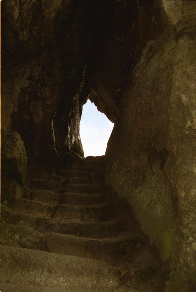
Pichu in the morning. The paths are good all the way. At first
it is a modern gravel surface, but after the pass on the second day it
is mostly paved with lots of stone steps. One the whole it looks like
modern paving on Inca foundations; to traverse the steep hillsides they
built big retaining walls, like their agricultural terraces. But from
time to time there was something undeniably original Inca, such as steps
cut into
the actual bedrock and sometimes even tunnels where they had enlarged
a natural fissue.
The trail starts near the Urubamba river a few kilometers downstream
from Ollantytambo. The river valley downstream narrows and twists and
turns before eventually passing below Machu Pichu (it finally becomes a
tributary of the Amazon). The trail, on the other hand, climbs up into
the mountains and arrives at Machu Pichu from above! The classic
postcard view of Machu Pichu is what Inca Trail hikers see when they
arrive.
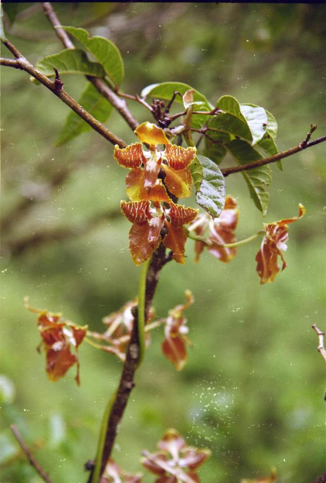
The natural history along the trail is interesting too. At the
start the vegetation is dry with lots of cactus, agave and air plants.
As it climbs it passes through some cloud forest, and then above the
tree line the terrain is open and not unlike British uplands (the
drizzly weather we had at the time added to this impression). Then down
the other side the trees return and are more tropical, with lots of
ferns, begonias (including a very bright neon orange one) and
orchids. We saw about four different orchids. I spotted the really
obvious pink one whose name translates as "always young" because it
flowers throughout the year. (Sadly the first flower we found was
a freshly picked-and-discarded flowerhead; we later found a big clump of
stems, more than a metre high, all but one of which had had their
flowers picked.) Christine's better-trained eyes also spotted the more
subtle brown-yellow-green flowers; one had a flower spike the size and
shape of a fern frond, made up of hundreds of little flowers. Another
had mostly-borwn flowers about an inch across on a winding climbing
stem. Although we had seen plenty of nice orchids in Monteverde's
orchid garden it was nice to finally see some in the wild.
We didn't see much in the way of fauna, apart from a few
hummingbirds (in spanish called piqueaflores, flower-pickers) and some
other little brown jobs. But another couple in our group were lucky
enough to see a family of spectacled bears near Machu Pichu. We were
jealous!
There are various Inca ruins along the way which provide good
places to take a rest. The suggestion is that they could be Tambos,
which means something like inns where travellers or the famous postal
runners would stop. But they also contain some high-quality
structures suggesting ritual significance, as you might expect on a
pilgrimage route, and possible defensive features. (The Incas
had only conquered this Amazon region a short time before the conquest,
so it was still frontier country.) One particular ruin, whose name
temporarily escapes me, was especially nice. Its water supply had been
reconstructed: a leat along the hillside brought spring water into the
site over a grooved-log aqueduct, from where it flowed through channels
carved into the rock to a series of fountains. Also, at this particular
site the cracks in the (not-highest-quality) stonework were full of
tiny plants. Lovely. But of course nothing compares to the remains
at Machu Pichu.
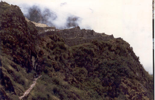
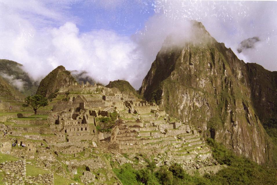
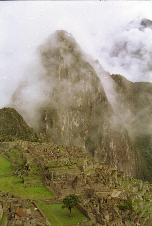
Machu Pichu
So, we've been to probably the second best known archaeological
site in the world
(I suppose that the Pyramids have to get first place).
Certainly the image of an expanse of stone
buildings on a high mountain saddle surrounded by tropical jungle is
an icon for the Inca civilisation, and probably adorns more than half
of the postcards that are sent home from Peru. And it is certainly
worth seeing. Here are a couple of my pictures (extra-large since they
are rather special).
First the gripes: the US$50 that we paid to get in wasn't enough
to include the toilets, and they have nowhere you can buy a guidebook or
even a postcard. And our guide - included in the Inca Trail package -
was useless! But armed with our trusty "Exploring Cusco" book we did our
own tour.
Arriving from the Inca Trail you first pass through an area of
agricultural terraces. These are separated from the "urban" area by a
water course where rock channels supply a series of ten fountains
whose construction quality - and presumably also the water quality -
is best at the top and most rustic at the bottom.
Above this is the "sun temple", a structure constructed from
high-quality stonework with some sort of astronomical / calendarical
function. One of the windows has some extra carvings which it is
suggested could have held a wooden thing to cast shadows on a carved rock
inside. From here there are further high-class buildings along the
top of the hill, looking down over terraces dropping down to the river
Urubamba at an angle of 80 degrees. These are separated from the more
utilitarian buildings by a relatively flat grassed area grazed by llamas
and alpacas. Then there's an area with two open-sided buildings facing
onto a square which it is suggested could have been some sort of
performance area. Along one of the other sides is a large upright flat
rock with a small raised "stage" in front of it; the rock could be
acoustically
useful, but also relects the outline of a mountain visible behind it.
From here we took a steep trail to the top of the adjacent mountain
(this is the one in the background in the classic views of Machu Pichu).
And it certainly is steep, with the steepest steps and smallest tunnels of
anything we've done. At the top are a few buildings and a good view down
onto the main site. There are also some incedibly steep terraces: it is
suggested that they are too impractical for normal agriculture, so perhaps
they could have been planted with bright flowers to add a splash of
colour to the view from below. It's pure speculation (unless someone
does a pollen analysis) but it's a nice idea!
Back in the main site we wandered around the utilirarian half of
the buildings, which included some odd underground grottoes and some
round things on the floors that could have been querns. And that was
about it.
We walked down to the river - about 400 vertical meters down I think
- through increasingly tropical forest with pretty plantanilla flower
spikes (banana-like things). Then after a late lunch it was time to
take the train back to Cusco - a trainspotter's delight about which I
may write more next time. Keep tuned for the next installment!
19 November 2002: Puno, Peru
Trainspotting Peruvian Style
No not Trainspotting the film (we went to see it in Lima, with an
audience of five, and I really wonder what the others thought of it) -
I mean two of the world's highest altitude and scenic train journeys
which we've done over the last few days.
Peru Rail operates
the recently-privatised Peruvian rail network. They're geared up mostly
for tourists and the trains are clean, prompt and yet still fairly cheap.
Our first trip was back to Cusco from Machu Pichu, and the second, today,
was from Cusco to Puno on the shores of Lake Titicaca.
The line from Machu Pichu to Cusco follows the Urubamba gorge to a
point above Ollantytambo, then climbs up a side valley on to the Altiplano,
before winding its way down to Cusco. For the first part of the journey
the line winds its way between the river and the cliffs, with views
down into the churning water to one side and up to snow-capped peaks on
the other. We did this bit in the light and it was quite interesting.
But once it got dark the excitement dwindled, especially as we knew that
the bus to Cusco from Ollantytambo was much quicker. Finally we crossed
the watershed and could see the lights of Cusco below us, with the
Inca ruins at Sacsaywaman and the Cathedral and Plaza de Armas lit up.
But from here it still took another hour to reach the station: the line
winds its way back and forth down the hillside, with two switchbacks when
the terrain gets too steep. Worth doing, but probably more interesting
in daylight!
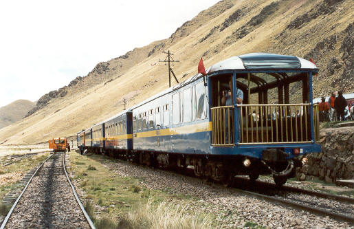
The Machu Pichu to Cusco line is narrow guage (about two thirds of
normal width I guess) so that it can get around the tight bends. Todays's
trip from Cusco to Puno was on full size rails because of the easier
terrain, and the train was a bit faster. Still it took us nine and a half
hours to do the 350-odd kilometers. From Cusco the line follows the city's
river downstream for a while until it joins another larger river flowing
from the east. It follows this valley all the way to its source at a little
over 4300m (Cusco is at about 3300m), crosses a pass and then descends
to the shores of Lake Titicaca.
The view for the first part of the journey as we left Cusco was a
depressing one of rubbish strewn everywhere. The locals seem happy to
tip their rubbish anywhere, especially if there is a slope to help it
roll away such as a river bank. When the rivers are in spate they spread
the stuff downstream, and plastic bags and mostly bottles decorate the
river's banks, gravel bars and adjacent fields and streets for miles.
Eventually we climbed above this detritus into the uplands: a wide
valley full of wet grassland grazed mostly by sheep and alpacas, with some
crops growing on the drier areas and up the hillsides. The mountains in
the distance looked about another thousand metres high, and at the top
some of them had quite a lot of snow on them.
At the very highest point the train stops for a few minutes so that
the passengers can get off, take some photos, and perhaps buy something
from the locals. They had the usual Peruvian stuff, but rather better
jumpers than we have seen elsewhere, so maybe Puno is the place for them.
But this point is really very high - at over 4300m, it's higher than
we've been so far on this trip and the highest I've been for ten years.
We've been above 3000m for nearly a month now and are reasonably
aclimitised yet still you notice that you need to take more breaths.
One of the passengers presumably hadn't had as long to get used to the
lack of oxygen and collapsed amongst the jumpers and toy lamas. They
gave him oxygen and sent him off to hospital at a slightly lower
altitude and we hear that he is recovering.
So from the summit the line descends to about 3900m, at which
point the valley flattens out: Lake Titicaca has been larger in the
past, and the line crosses the ancient lake bed. The last city
before Puno is Juliaca, described in most unflattering terms in our
guidebook; the train seems to go down the middle of the main street,
barely missing the market stalls on either side. (Juliaca market
seems to sell everything you could think of a use for, and plenty of
things you couldn't, including whole stalls selling rusty old gear
wheels and used car tyres.) Finally the lake
becomes visible. Along the edges are small cultivated areas with
probably potatos. In the lake itself there are lots of reeds, and
I noticed a couple of piles of them on the shore. ¿What are they
going to use them for? I asked myself - and the answer was apparent
a few seconds later when we saw our first Lake Titicaca Reed Boat.
Shortly afterwards we actually saw a boy punting one of them out by
the reeds. They have wooden boats too, but the reed boats realy
seem to still be in use.
So now we've arrived in Puno, the main town on the Peruvian side
of the lake. It's main tourist attraction is the boat that was famously
made in Glasgow and brought up from the pacific in 2000-odd pieces by
mule. Then we have to decide which of the islands to visit. We don't
really know what we're going to do next, but we're glad to have
finally left Cusco!
22 November 2002: Puno, Peru
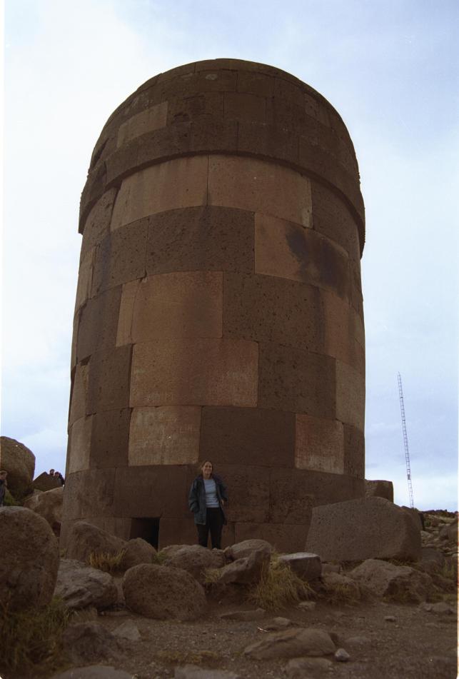
Sillustani
Our first outing from Puno was to Sillustani, a pre-Inca archaeological
site about 40km to the North. It's a group of about sixty tomb-towers,
about half a dozen of which are still quite substantial. They say that
the Incas didn't invent anything new but just copied the best of all the
previous cultures, and the stonework here is certainly up to Inca
standards - though it seems to be made from easier-to-work stone than
the things in Cusco and Machu Pichu. The towers are built on a
peninsular on a lake and there are some quite photgenic views.
On the way back we stopped off at a "traditional country house",
a mud-brick place where some locals will show you their kitchen and sell
you some souvenirs. It was actually really interesting: they have two
different sorts of preserved potatos, and we got to try them with the
local cheese or, for the more adventurous, a spoonful of clay!
Finally on the way back to Puno we were treated to a very spectacular
thunderstorm with the most enormous flashes of fork-ligtening over Lake
Titicaca.
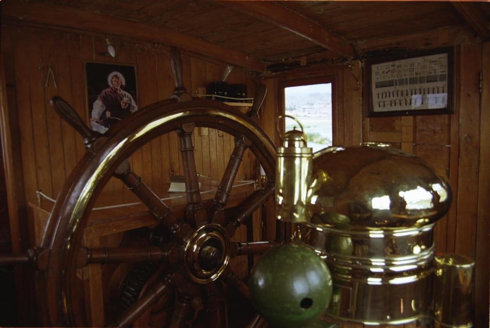
M. N. Yavari
The Yavari is the famous boat that was built in Britain, cut up
into more than two thousand pieces, shipped to Peru's Pacific coast and
carried up to Titicaca by mule. It's an astonishing story, and the
boat ouses history. All the bits have brass plates on saying where
they were made - from all corners of the country. We spent an hour or
so being shown around by one of the local restorers. Excellent.
(Do have a look at the Yavari web site:
http://www.yavari.org - I have just learnt that the
muleteers who won the contract to carry the bits up to the lake said
that they would do it in six MONTHS, not the six YEARS that it actually
took!)
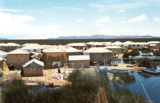
Islands of Lake Titicaca
We've spent the last couple of days doing a tour of the islands in
the Peruvian end of Lake Titicaca. Of these the best known are the
Uros "floating" islands, and we stopped there first for an hour or so.
The bay outside Puno is shallow and full of reeds. The Uros islands
are built up from bundles of reeds and are actually quite substantial.
The surface is dry and although you do sink in a bit if you stay in the
same place for a while it is not the swaying wobbly place you might
imagine. Apparently they have a school and health center, and most of
the buildings seem to be wooden with corrugated iron rooves. But the
bits that the tourists see are all constructed from reeds. You get the
impression that these people could build anything at all from reeds!
We took a short trip from one island to the next on a reed boat before
getting back on our proper boat for the trip to Amantani.
I have chosen a picture that shows some buildings that people
actually live in, rather than the tourist places. The "ground" in the
background is actually a reed bed and definitely not terra firma.
Amantani, where we spent the night, is a terra firma island beyond
Puno Bay in the lake proper. It took about four hours to get there in
the most flat-bottomed boat I have ever been in. Looking at the surface
of the water you would probably call it "almost calm" - the waves were
barely more than a foot in height. But this keel-less thing was
rolling all over the place! Not a trip for those prone to sea sickness.
Anyway, we got to spend a couple of hours climbing to the highest
point on the island, where there is some sort of temple, before it got
dark. There are no hotels on the island and visitors are allocated to
a family who feed and house them. The guidebook warned us to expect
"three meals of remarkable similarity" and indeed we got vegetable
soup, potatos and cheese, rice and chips, and deep fried egg white.
Then in the evening we were treated to some local entertainment:
a cacophony of pan pipes, guitar, drums, and a very squeeky recorder.
Apparently if we had stayed later we would have got to join in some
dancing, but it was too much well before that...
Then this morning we crossed - in much calmer conditions, thankfully -
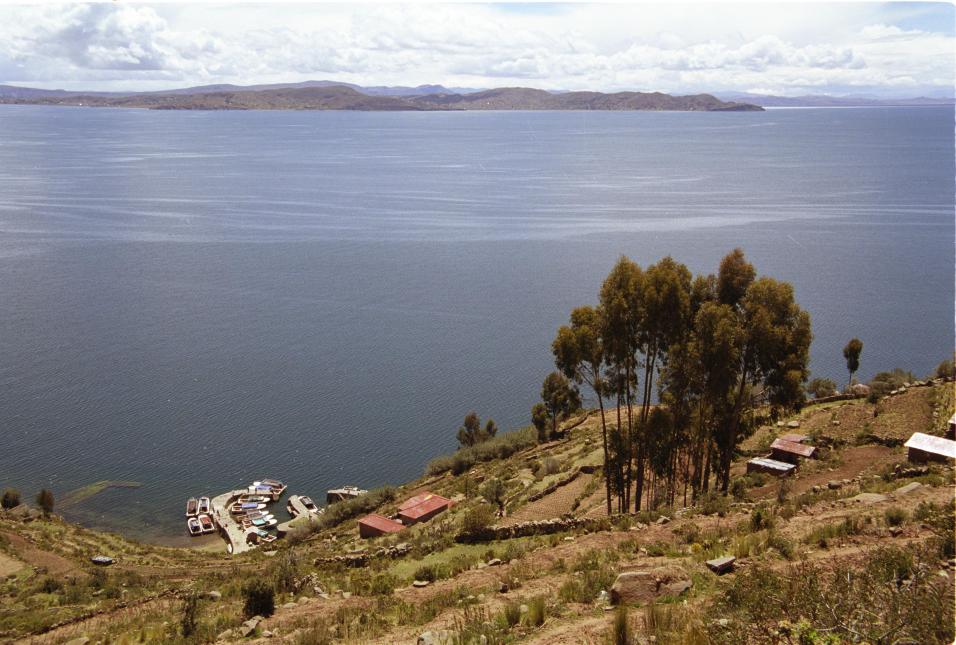
to Taquile. Taquile is closer to Puno and a bit more touristy, but still
there isn't much to do there apart from walk around looking at the view
of the lake and visiting the craft cooperative. Both islands have
places where the locals sell their knitting and weaving. In fact on
Taquile, almost everyone seemed to be spinning or knitting just about
all the time! Although we've seen women in traditional dress in most
of Peru, on Taquile it seems to be normal for the men too. They have
a tradition of wearing a hat with a white top until they marry when it
is replaced by a red patterned one. So you won't be surprised to hear
that we didn't escape without making a few purchases...
So this is our last night in Puno, and our last in Peru.
Tommorrow we're taking the bus to Copacabana on the Bolivian side
of the lake.
© 2002 - 2003