New Zealand
25 February 2003: Auckland, New Zealand
Well I have finally arrived in New Zealand - only two and a half
months later than originally scheduled! I am going to have to get a move on
if I'm going to get home before time and money run out, but it looks like
there will be plenty to keep me occupied for the next few weeks in this
part of the world.
It was good to enjoy a flight that was not in the middle of the night
and crossing lots of time zones for a change. For some reason most of the
pacific islands only have flights at three o'clock in the morning! I was on
the one flight of the week from Rarotonga to Auckland that takes off
during daylight and the captain was good enough to take us on a circuit of
this island at 2000 feet. It's very picturesque and I regretted not having
seem more of the interior, despite the humidity and mosquitoes.
First impressions of New Zealand - i.e. the inside of Auckland
airport - were good. They have very strict (though apparently not entirely
effective) regulations to keep out pests and diseases but the "enforcers"
were friendly and reasonably efficient. Something I noticed straight
away was a symptom of the recent privitisation frenzy here: everything
that used to be a public body now has a "New Speak" privitised name.
The people who do this really ought to read 1984 first.
The first one was what used to be Customs Service, which is now called
"Frontiers New Zealand". But this is nothing compared to what used to
be the publicly-owned railway network. Prepare yourself for a ghastly
pun. This is now called "TraiNZ".
Auckland
I have arrived here in just in time for the finals of the Americas
Cup (the big yachting race). Not surprisingly there was not much (i.e. no)coverage of this "Super-rich man's sport" in South America and I didn't
know it was happening until I got to Rarotonga! But there is not
much getting away from it here - even the airport information screens
had been hacked about so that the score was displayed among all the
flights. But it is not exactly a spectator sport. It is possible to
take a boat trip to see the start but that's expensive. So if you see
the highlights on the telly you know as much as me.
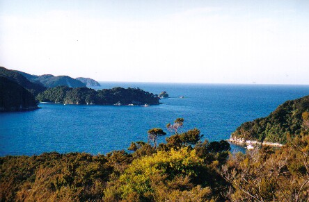
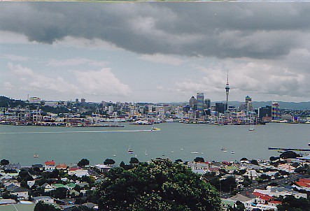
Auckland seems to be quite a pleasant place; it is quite like
Vancouver in many ways, with some nice coastline nearby and a big
harbour. The North American feel is in evidence in the city too with
their style of road layout and, for example, writing "Way Give" in the
road instead of "Give Way". But there are aspects that are like home
too: they drive on the Left of course and the city is full of
Stagecoach buses in the same livery as the British ones. Here is a view
of the city centre from over the water in Devonport:
Today I went to the Maritime Museum, which has a nice collection
of traditional boats from the polynesian islands and an annimated
film about the first Maori settlers. Then there is the usual
reconstruction of the interior of an 1850s immigrant ship and a 1950s one
for comparison. (There is something similar in Liverpool's maritime
museum; Auckland's version has a gentle rocking motion to induce
authentic seasickness in all the visitors.) And moored outside are
a few historic ships, including Rapaki, a huge steam-powered floating crane
made redundant in the early 90s due to containerisation. It was made
in Paisley in the 1920s, the crane mechanism itself by the same people
who built the Forth Bridge - and it is about as rusty. Reminiscent of the
Yavari in Lake Titicaca it had quite an eventful journey from Britain:
despite not being what you would think of as an ocean-going vessel it
came all the way via the Panama Canal under its own steam and nearly ran
out of coal in the process! Also like the Yavari it had a dynamo made
in the West Country; the Yavari's in Yeovil and Rapaki's in Bourton,
near Gillingham in Dorset.
In a few days I will be heading South; the big tourist attractions
in the North island are the geothermal things at Rotarua and the caves
at Waitomo (I am finding these Maori names difficult: they all look the
same! I think they have fewer consonants than we do). There are a couple
of big volcanos too where there may be some good hiking. But I can't
spend too long here if I want to get to the Southern Alps and the big
mountains before the end of summer.
But first there is something I want to do near here: I want to
visit the Rainbow Warrior memorial. (For the benefit of the very young
or ignorant, the Rainbow Warrior was a Greenpeace boat that was bombed
by French secret agents in 1985 while it was moored in Auckland harbour,
killing one of the crew. I think it's a perfect example of how one
nation's terrorists are another's heroes, and we could learn a lot from it.)
Anyway I thought, for some reason, that the memorial was "just North
of Auckland", but it turns out to be miles and miles away with no
public transport, which seems odd for Greenpeace. (The boat itself was
dumped on the seabed as an artificial reef and divers can visit it to
see the fishes.) So I may be spending the next couple of days
hitch-hiking there and back.
Well that's all for now. Do have a look at the underwater pictures
I have just scanned in from the Cook Islands.
28 February 2003: Auckland, New Zealand
Paihia and the Bay of Islands
I have spent the last couple of days up in Paihia in the Bay of Islands;
a nice bit of coastline with good beaches and lots of surfers.
Unfortunately it was pouring with rain for a lot of the time I was there
but somehow I managed to not get too wet.
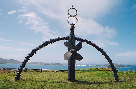
The Rainbow Warrior Memorial
My main reason for going there was to visit the memorial to the
Greenpeace boat Rainbow Warrior which was blown up by the French in
Auckland harbour in 1985. The remains of the boat were sunk in the
bay of islands and a memorial was built on a cliffy headland above
Matauri Bay. It's not an easy place to get to, but after five hours
on a coach, 60km hitch-hiking (which seems to work quite well here),
and a short walk I eventually got there. The memorial has the boat's
propellor and a "rainbow" of stones:
Not surprisingly there were not a lot of people around and I had
just enough time for some peaceful contemplation between rainstorms...
The Waitangi Treaty
Having gone all that way I couldn't just come straight back to
Auckland, so I went to see the Waitangi Treaty site just outside
Paihia. The Waitangi Treaty was the agreement by which the Maori
ceeded sovereignty to Queen Victoria in 1840. They have preserved
the house where the British Resident lived - he was an interesting
chap by all accounts; he was the first person to grow grapes and
make wine in New Zealand and wrote books about it. You can also see
a huge Maori war canoe that was built for the centenary in 1940;
it is vast, built from three enormous hollowed-out tree trunks
spliced together. They did most of the hollowing-out where the
trees fell, but it still took a team of 22 bullocks to drag them out
of the forest!
Unfortunately some of the historical information is a bit hard
to understand unless you know some maori. I suppose that the New
Zealanders learn some at school, but for us foreigners it is not
easy to understand things like this: "Each iwi within Aotearoa today
traces it whakapapa to an ancestral migratory waka." To be fair
they did translate whakapapa as geneaology and many visitors will
have worked out that Aotearoa means New Zealand, but what this display
panel was trying to say is still quite a mystery to me.
Next stop Waitomo to see the caves.
3 March 2003: Rotorua, New Zealand
Waitomo Caves
I've been travelling for more than six months now and I've only
just visited the first cave of the trip! (Well, that's if you don't count
the lava tube cave on Easter Island, which I don't think I do.) So to
make up for it I went to not one but two!
It seems odd to me that New Zealand has limestone since not far
from Waitomo you can see the geothermal activity and volcanic peaks
where the Pacific plate meets the Austalian plate (or whatever that one
is called). But they do and there are some quite substantial caves
at Waitomo, about half way down the East coast of the North island.
What makes these caves special is that they aren't as pitch black
as almost all others - they are full of Arachnocampa luminosa
larvae, or glow worms to you and me. The adult insects lay their eggs
on cave roofs and outdoor rock overhangs. When the larvae hatch they build
themselves a "nest", which is a tube made of a mixture of mucus and
a silk-like material. From this tube they dangle silk filaments coated
with sticky blobs. And they sit and wait, spider-like, for something to
wander into their trap. Mostly they prey on insects that have wandered
into the cave by mistake. But the crucial thing is that they lure their
prey with light. A chemical reaction in their gut gives off a green-white
glow and seen from below you can forgive an errant gnat for thinking that
it was looking at the star-studed sky.
So I took the regular trip to the glow worm caves, which starts off
like every guided cave tripin the world with a selection of formations that
look like elephants, old women and similar rubbish. But then you get in
a boat and float gently downstream with the lights off looking up into the
roof of the rift passage where they say there are ten thousand glow worms.
It really does look a lot like the night sky, though whereas the stars are
randomly distributed these creatures seem to keep a minimum distance from
their neighbours. It's absolutely fabulous and not to be missed.
But for some more excitement I also went on a "black-water rafting"
trip, which involves putting on a wetsuit and floating through a similar
cave sitting in a big inner tube. It might have some similarity to
(outdoors) white-water rafting when the water level is higher, but for
us it was quite gentle and we had plenty of opportunity to enjoy the
view of the lights in the roof.
Finally, Waitomo has a Cave Museum which is also excellent; it has
a great audio-visual about the glow worms and some interesting stuff
about cave exploration, geology, and cave life - including a live cave
eel in an aquarium! I thoroughly recommend all three.
So this morning I packed up my tent (in the rain...) and came to
Rotorua, in the centre of the North Island and near to the most famous
volcanic activity. You can smell the sulphur as soon as you get off
the bus! So far the town looks rather uninspiring, but I'll see what
there is to do over the next couple of days.
10 March 2003: Wellington, New Zealand
Rotorua
Rotorua is a major tourist centre in the North island because of
its volcanic activity and maori cultural significance. I spent a day and
a half there and visited two of the geothermal areas.
First I went to the Waimangu valley, which I chose because it had
won all sorts of awards for environment-friendly tourism. The geothermal
activity started in 1886 when Mt Tarawera errupted; it was a huge
erruption with about two cubic kilometers of lava being ejected in less
than four hours! The erruption was along a row of vents from the summit
of the mountain into the surrounding countryside, and the Waimangu visitor
attraction is in the valley of these vents. There are various hot springs,
steaming lakes and water-filled explosion craters to look at.
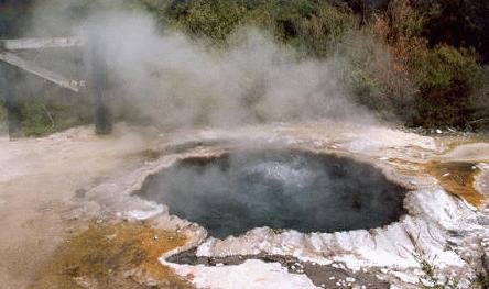
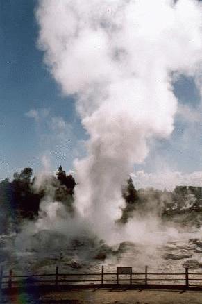
The second place I went to was the Whakarewarewa thermal area, which
is on the outskits of the town of Rotorua and is looked after by the
Maori Arts and Crafts Institute; there is also a traditional Maori village
and intricately carved meeting house to look at. This hot pool was
traditionally used for cooking:
They have a couple of geysirs, and in fact these are the only active
geysirs in New Zealand. This one seemed to be constantly ejecting lots of
water and steam but I didn't see it errupting properly.
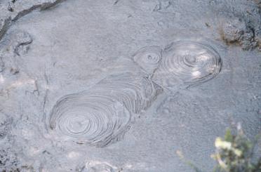
And of course there were lots of bubbling mud pools.
I didn't stay in Rotorua for long because the weather was good and I
thought I ought to go and make the most of it while it lasted. So I set off
to visit the Tongariro national park.
Tongariro
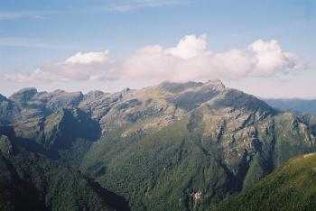
South of Rotorua, Tongariro is part of the same volcanic chain.
There are three big volcanoes: Tongariro itself in the North, an old eroded
mountain, then the incredibly new Ngaururhoe, and in the South the higher
peak of Ruapehu, which catches most of the precipitation and has been
developed as a ski centre. I spent three and a half days doing the
Tongariro Northern Circuit, with side trips to the summit of Ngaururhoe
and Tongariro's northern crater.
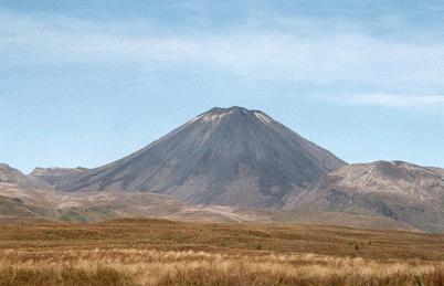
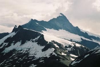
This is Ngaururhoe, 2291m high and only 2500 years old!
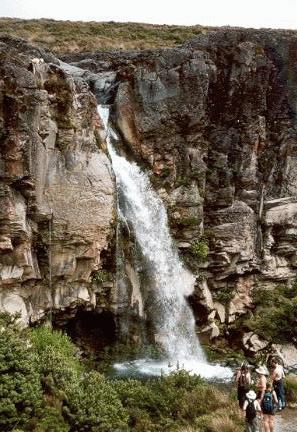
At the start of the circuit the path passes this impressive waterfall,
Taranaki Falls, which make an easy day walk. There are fewer people on the
path after this.
The first days's walk, to the hut at Mangatepopo, was very short.
The huts on this walk are excellent; they have gas heating (not needed at
this time of year) and stoves and matresses for a couple of dozen people.
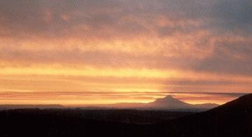
There was a spectacular sunset from the hut:
the sun went behind Mount Taranaki, a
dorment volcano to the South East.
Day two is the longest day, and a lot of people do it as a day walk -
the so-called Tongariro Crossing. I took a side trip to the summit of
Ngaururhoe, which involved a lot of three-steps-forward, two-slides-back
to get up the slopes of very light pebbles. At the top you are rewarded with a
sudden view down into the overhanging crater, which must be
less than a hundred metres in diameter. It's not active and in fact there was
a patch of snow in the bottom.
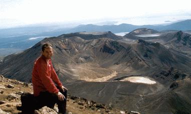
The view from the top was also well
worth seeing. Here I am sat on the top. Behind me you can see the flat
top of Tongariro's north summit, the Blue Lake and in the distance lakes
Rotoaira and Taupo.
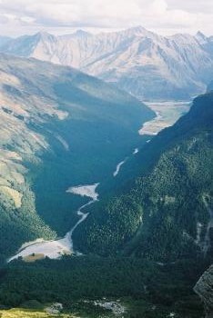
From Ngaururhoe the route heads North through a couple of dry,
flat-bottomed "craters"
that are actually glacial cirques rather than volcanic features. On the way
you pass the Red Crater, an active crater from which sulphurous smells
and steam emerge, and the Emerald Lakes, three small lakes coloured by
minerals from the Red Crater.
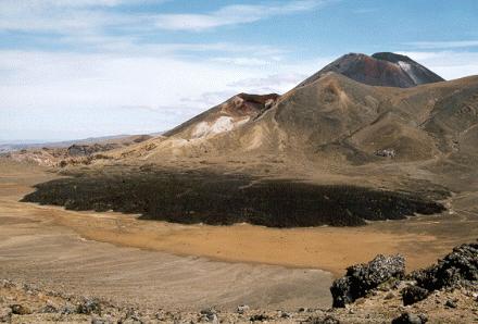
Here is a view looking back to Ngaururhoe later in the day. In the
center is the Red Crater, from which the black lava flow in the foreground
must have come quite recently.
The day finished at another excellend hut with a view Northwards
over lakes Rotoaira and Taupo. I had been the only person in the hut at
Mangetepopo, but at this one there were about a dozen of us, including
a group of four desperately ill-prepared english lads. They had brought
no cooking or eating things so they were constantly borrowing from the
rest of us, and were hoping that their four litre bottle of fresh milk would
last, unrefrigerated, for the three day walk! And I think only two of them
actually had sleeping bags!
The next day I climbed back up the seemingly-unending zig-zags above
the hut and then up to Tongariro's northern summit. This is a very
large, flat, round summit whose geological origin is fascinating. At some
point Mt Tongariro had a summit crater lake of molten magma which slowly
cooled and solidified into hard basalt. During subsequent glaciation much of
the rest of the volcano, made from softer material, was eroded away. Now
all that is left is the flat surface of what was once the molten lake. (You can
see it in the self-photo from Mt Ngauruhoe above.)
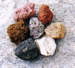
There are lots of different kinds of rock here. I collected these
seven different colours on the slopes of the northern summit.
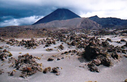
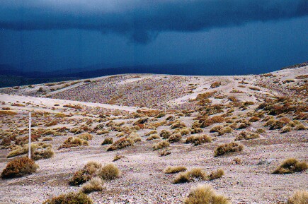
I spent the afternoon descending the East side of the mountain to
the next hut. This side of the masif must get relatively little rain and the
terrain is quite desert-like, with old lava
flows and lots of ash and sand.
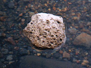
Pumice is one very common rock here; an erruption at Taupo in 186 A.D.
ejected many cubic kilometers of the stuff which forms a layer up to several
metres thick over much of the area. There was some very similar stuff at
Askja in Iceland (the place where I swam in the crater lake) which
apparently was found as far afield as Stockholm. Anyway here is a big
lump of it floating in a pool:
Later on clumps of vegetation appeared amongst the sand. Luckily the
dark clouds in the distance didn't get any closer and just added a more
interesting background to my photos:
After a final night in another excellent hut
I returned to my starting point at Whakapapa.
Miraculously it stayed dry and sunny for the entire time and overall
it was a great walk.
Getting Around in New Zealand
It's time for a few annecdotes about getting around by bus, train and thumb
in New Zealand.
New Zealand doesn't have a particularly good road safety record. They
have about twice as many road deaths per person than Britain, though it's
still better than the U.S.A. or places like Greece and Portugal. The minimum
driving age is only 15 and insurance is not compulsory. Bus drivers seem to
be no safer than drivers in general.
My first bus crash happened about one second after setting off from Auckland
bus station. The stupid plonker at the wheel didn't close the luggage compartment
door before pulling away. It smashed into the back of the bus in front, doing a lot
of damage to both vehicles. The driver effected a temporary repair using the bus
driver's only tool, the "big spanner", with which he hit the door repeatedly until it was
approximately flush with the side of the bus again. So we eventually set off about
half an hour late.
The next interesting incident was on my way from Rotorua to Whakapapa.
This was in a smaller bus with a very "friendly" driver. He spent all of his
time making conversation with the passengers, apart from when he was talking
on his mobile phone. At one point he used one hand to hold his phone to his
ear, another to change gear and his knees to steer. I put up with this silently,
my palms slowly getting more and more sweaty, until he started trying to talk
to me. I told him, as politely as I could, that I'd rather he concentrated on driving
rather than talking to me. He took great umbridge at my suggestion that his
driving was anything less than perfect and threw me off the bus. This turned out
to be a good thing since it happened in Whakapapa, which I found to be a much
nicer place than my intended destination of National Park.
When I had finished my walk I decided to try the train for a change. So first
I had to get from Whakapapa to National Park, the nearest place with a railway
station. I didn't want to risk meeting the same bus driver and decided to hitch-hike,
which was a good choice: the second car to pass stopped for me after I'd been
waiting for only about thirty seconds!
Buying a train ticket was the next exciting adventure. Naturally I started by
going to the railway station, but the station turns out to be a bar-restraunt and
doesn't sell tickets. If you want to buy a ticket you have to walk a mile to a
hotel at the other side of town where they do sell them. So I went there and yes,
the lady behind the counter said she could sell me a ticket, but "it's a long time
since I've done this and I haven't got my glasses so please bare with me".
She had to phone the TraiNZ helpline and get them to help her fill in the ticket -
"And where do I write that? Oh, in this box that says date? And where do I
write that? Oh I see." And so on.
So at two in the morning I went back to the station and the train did
eventually arrive and I did eventually get to Wellington. It was probably
the least comfortabl overnight journey I've done on this trip - even less
comforable than Peru's overnight buses, though quieter. Overall,
hitch-hiking seems like by far the best option.
I am now in Wellington, contemplating where to go next. Just over the
Cook Strait at the top of the South Island is the Abel Tasman national park
where various people offer sea kayaking trips. Might be interesting for
a change!
18 March 2003: Nelson, New Zealand
Abel Tasman National Park
I've spent the last few days in the Abel Tasman National Park, which
is just West of Nelson on the North coast of the South Island. It's a
lovely coastal area with lush wooded hillsides dropping down to rocky
headlands and golden sandy coves.
I signed up for a two-day sea kayaking trip along the coast. My
plan was to spend the following day returning to the starting point on foot
along the coast path.
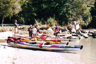
There were eight of us in the group: a family of three from the U.S.A.,
one German and four from England. We were all in double kayaks; I shared with
Andy the German who I am sure provided more than his fair share of the
propulsion! Here we all are - much too small to see I'm afraid:
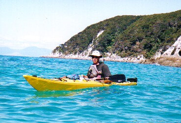
Then there was our guide, Sam, who told us what to do, found us the
best places to camp, and produced some great meals from his boat's seemingly
bottomless food locker:
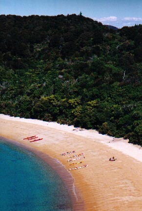
The pace of the trip seemed to be quite gentle, yet we covered plenty
of distance. Kayaks seem to be pretty efficient ways of getting
around, as I found out when I travelled about the same distance to get
back on foot. The coastline is lovely. Here is one of the first of many
golden sandy bays that we stopped at during the trip:
There is a well-engineered coastal path that winds its way along the
hillside, often high about the beaches with good views like this when there
is a gap in the trees.
Once again the weather stayed excellent for the duration - it was
bright and sunny, and calm, all the time. And even the sand flies,
for which the Abel Tasman area is apparently renowned, were not too
troublesome. I had a great time!
I'm now back in Nelson and tommorrow I'm taking a bus southwards
down the West coast as far as a place called Punakaiki, which is midway
between Westport and Greymouth in the Paproa national park. This area has
a range of high (about 1200m) granite mountains inland and a limestone
area, with caves, between them and the sea. I'll let you all know what
I think of it.
24 March 2003: Franz Joseph, New Zealand
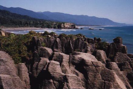
Punakaiki and Mount Bovis
When I left Nelson I took a bus down the West coast and got off at
a small place called Punakaiki. It's a popular place for a short stop
to look at the "Pancake Rocks" - the limestone is oddly eroded by the sea
and looks like stacks of pancakes! Amongst all these flat rocks there are
a few blow-holes that could look interesting when the tide is in and the
sea is rough.
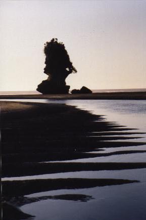
At the other end of Punakaiki beach there is some other spectacular
erosion going on. How much longer will this stack last I wonder?
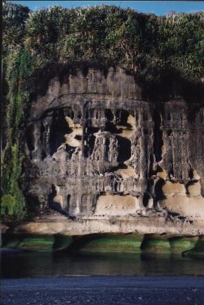
Then there is this odd cliff whose base is being cut back by a river
reaching the sea, with a bright green algae band marking the high tide. I
took these pictures just before sunset and everything looked very
picturesque.
But I decided to stay for longer and see some more of the Paparoa
National Park, of which the Pancake Rocks are just the most visited corner.
Inland there is a range of 1000m-plus granite mountains, but between
them and the sea there's a belt of limestone a few kilometers wide.
So the water runs off the mountains and sinks into caves, to emerge later
in classic steep-sided limestone canyons emptying into the sea. This is
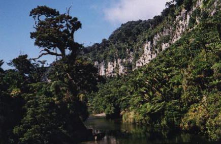
the Paparari river canyon where I started my walk:
Apart from the very tops of the mountains, and a few areas cleared
for farming, the whole landscape is quite densely forested. I spent one
day walking inland on an old settlers' track, alongside a river through
a canyon, and then pitched my tent in a clear area at the top of "Bullock
Creek". An appropriate name as it turned out. Anyway, on day two I set
off up Mount Bovis, a 1250-odd metre peak. It shouldn't have been too
much of a struggle, but it took me ages. The first three or four hours
were steeply uphill through the jungle on a hint of a path, climbing
up staircases of tree roots and squeezing between giant ferns. All very
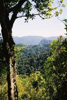
tiring and not much view, and quite reminiscent of Middle Earth! Here is
one of the few views that I got on the way up:
Eventually I emerged above the tree line and the top was in sight, and
finally there was also a view of the other mountains in the vicinity.
The highest were over 1400m; in a few places they were quite rocky, but
mostly the ridges would be walkable. But I wasn't going to have time
to go beyond the top of this peak.
Getting from the tree line to the top took another hour. It got
quite scrambly at the end. Here is a view of some of the other Paparoa
summits, most of which are named after famous scientists:
Then I had to do it all in reverse to get back
down. I just about managed to get down before it got dark, which was
certainly a good thing. (They mark the route with bits of white stuff
like venitian blind material nailed to trees, and a few orange triangles
which on close inspection turn out to be not quite eqilateral and are
supposed to be arrows. But none of these glow in the dark!) Then came
the excitement of getting back to my tent. As I walked along I could
detect various large dark things out in the gloom and I suspected that
they could be cows. Eventually it was really dark (there was no moon)
and I got out my headtorch; the creatures were attracted by this and I
was very grateful for the flimsy not-properly-shut gate between me and
about a dozen pairs of glowing green bullock's eyes! I was actually
quite petrified as I heard the "distant thunder" noise of their feet
first and had no idea if they were going to stop.
Anyway I survived and the following morning walked back to the
coast and got on a bus South to Greymouth, a largish town by West Coast
standards that looks like it just survived the departure of the
gold miners a hundred years ago! And after stocking up in its
supermarket I made my way to Franz Joseph, capital of New Zealand's
Helicopter Country (oh and it has a famous glacier). More about that
later.
25 March 2003: Queenstown, New Zealand
Franz Joseph Glacier
The Southern Alps have quite a lot in common with the Patagonian
Andees, especially in terms of their climate and vegetation. Lots of
wetness arrives from the West and dumps loads of snow over the mountains,
and leaves the land on the East side very dry in comparison. All that
snow - the equivalet of four to six metres per year both in Patagonia
and here - slowly oozes down the sides of the mountains as glaciers that
almost get down to sea level.
I saw plenty of these low-altitude glaciers in Argentina and Chile.
Here they're not quite as huge but they're still quite spectacular, and
lots of tourists are attracted to the two most accessible ones, the
Franz Joseph and the Fox. I spent a couple of nights in the township
of Franz Joseph and spent a day hiking up the hillside above the glacier.
Mountaineers had been coming to Franz Joseph for many years. In
the local information office they have some nice old photos of Edwardian
ladies dresed in huge skirts, clasping ridiculously long ice axes, high
up on the glacier. And out the back they have preserved an old corrugated
iron hut, used by climbers
on their way up to one of the peaks wanting to get an early start.
But it seems to me that this mountaineering activity is all in the
past. The hut was removed from the mountainside in 1978, and another one
on the opposite side of the glacier is now preserved as a purely historical
structure. Today's visitors seem to want to experience the ice and the
mountains without going to the trouble of exerting themselves climbing
up them. We are now in the age of the Heli-Hike.
Franz Joseph township has about half a dozen helicopter companies
and the place is constantly buzzing with the noise of the machines
as they put down one load of passengers and pick up the next. But of
course the noise is not limited just to the town. As one climbs up what
should be an idylic alpine hillside with just the noise of a few wild
birds and maybe odd creaking noises from the ice below, there is an
almost constant drone of helicopters, and the odd plane, overhead. The
place is quite ruined by it.
There were also helicopters in Tongariro National Park, and when I
was in Punakaiki there were petitions out in many of the cafes protesting
about a proposal to helicopter people around the Pancake Rocks. I
believe that they need to be authorised by the Department of Conservation,
who seem to have quite strict policies in most other respects. So why
they allow this intrusion I do not know.
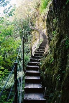
Anyway, I did a walk up to "Roberts Point", a viewpoint overlooking
the glacier. It is an interesting path view a few bridges and these
very well made steps to get up a practically overhanging cliff face:
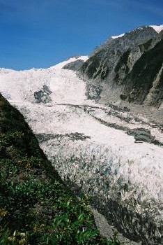
Here is the view of the glacier from the end of the path. Actually
according to my GPS this wasn't Roberts Point at all - that was another
few hundred metres around the corner. I guess that the last bit of the
path has been closed for some reason.
It seems that the helicopters from Franz Joseph, Fox and the town
of Mount Cook on the other side of the range cover pretty much the
entire of the Mount Cook National Park between them. So I have given
up on that area and come further South in the hope that the slightly
more remote Mount Aspiring National Park will be more peaceful - more
of a National Park and less of a National Playground. I will let you
know how I get on.
1 April 2003: Melbourne, Australia
Mountain Biking in Queenstown
So I took the bus from Franz Joseph glacier all the way down to
Queenstown, which is known as New Zealand's "adventure sports mecca".
People from all around the world come here to bungy jump from bridges,
throw themselves out of planes and other equally high-adrenelin
activities. I was only there for a day and did something relatively
sedate: I hired a mountain bike and spent a few hours cycling up to a
pretty lake and back. Here's a picture of my destination. The
landscape this side of the mountains is indeed much drier than the
other and the hillsides are quite bare, making it look more like the
English Lake District than anywhere that I've been for a while.
Wanaka and Mount Aspiring National Park
From Queenstown I went back North to Wanaka and then set off into
the Mount Aspiring National Park for a few days camping. My plan was to
climb Sisyphus Peak, a snow-free mountain from which there should be
good views to the higher and glaciated Mount Aspiring itself and its
neighbours. (I have just done some internet research to find out who
Sisyphus was. According to
http://www.pantheon.org/articles/s/sisyphus.html
in Greek mythology he was "sly and evil and used to way-lay travelers
and murder them"; as punishment in the underworld
"he is forced to roll a block of stone against a steep hill, which tumbles
back down when he reaches the top. Then the whole process starts again,
lasting all eternity". So an appropriate name for some mountains, though
to be honest I don't think this peak deserves such a harsh comparison!)
Sisyphus Peak is remote enough to need a three-day trip; one day to
walk in, one to climb to the top and back, and a final day to walk out.
The first and last days were easy enough, following the banks of the
East Matukituki river up from the road. At first the valley is quite
wide with cattle and sheep farming, but then it narrows and the path is
forced up into the wooded hillside. Then the valley opens out again at
Junction Flat, where the route turns left into a tributary valley, the
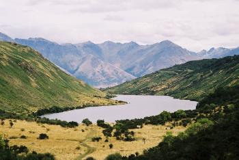
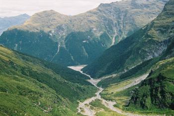
Kitchener. This photo shows the East Matukituki valley, from the start
of the walk in
the distance up to Junction Flat in the foreground.
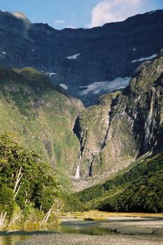
I walked up the Kitchener, still on a fair path, as far as
Kitchener Flat where the Rainbow Stream joins and there is a good camping
spot. (There is also a dry bivvy site under an overhanging rock, but as
the weather was nice and dry I chose the green patch with the view!).
This is a view of the upper Kitchener valley from near my campsite: like
all the streams in the area it starts as glacial meltwater.
The next day's walk started by crossing the Kitchener River. It was
not too difficult once I had found a shallow spot: only knee-deep and not
flowing too quickly. Then I spent the next few hours slowly ascending the
Rainbow Valley, which involved more stream crossings, this time over a
smaller but swifter stream that was just too wide to jump. Each time I
took my sandals off and put my boots back on the river meandered to the
other side of the valley and another crossing was needed!
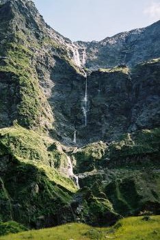
All the way up the valley there were views of tall thin waterfalls
cascading down, presumably with glacial meltwater from the hanging
valleys high above. As I got higher the snow-capped peaks slowly came
into view.
Eventually
I got to about 900m (my campsite was at about 500m) and left the stream
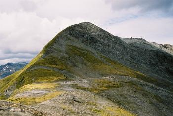
behind to climb up the hillside. The vegetation slowly thinned out and eventually I reached a barren rocky col at about 1700m. From the col
it was a quick easy hike up to the top at about 1850m:
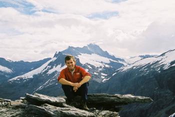
The view from the top was good: there were big snowy mountains and
glaciers to the West and North, and deep valleys, including the ones that
I had walked up to the East and South. Here I am on the top with
Mount Aspiring (a touch over 3000m) in the distance:
And here's a closer view of the mountain:
But I didn't have much time to admire the view. I had been very
slow on the way up and since the clocks went back it was going to get
dark quite early. So I set off down promptly. Rather than retrace my
steps I had decided to take a more direct route, but this turned out
to be a bad idea: I spent a lot of effort slipping and sliding down
through the unpleasantly dense and sometimes spikey vegetation.
It actually got dark as I was getting back to
the bottom of the Rainbow Stream valley and I was very pleased with
myself for having taken a GPS fix on the place where I had crossed the
Kitchener River; if I hadn't I would never have found it and might have
had to wade through waist-deep glacial-cold water! So I got back to
my tent after eleven hours, thoroughly tired.
After all that the walk back the next day was a piece of cake.
I got a bus back to Wanaka and then another all the way to Christchurch
the same afternoon. And the next day flew to Melbourne.
© 2002 - 2003