21 June 2003: Seoul, Korea
Seoul
I've been in Seoul for a week now which has given me plenty of
time to explore in and around the city. I'm staying with Andrew Ward,
who is a friend from Manchester and
has been the Financial Times correspondent here for the last year
or so, and his wife Jayne. They have a flat that is maybe a tiny bit
bigger than my place in Cambridge was i.e. just about big enough for two
but hardly for three, so I am grateful to them for putting up with me.
Seoul is a big city - more than ten million people - but I think that
most of them live in high-rise buildings so the city is not as big
in terms of area as it could be. It has a very extensive and efficient
metro and bus network, and lots of signs and information is at least
bilingual (often quadrilingual), so it is easy to get around.
Korea doesn't have a very happy history. They were occupied by the
Japanese not once but twice, most recently from 1910 to 1945, and they
still seem to be recovering in some respects. For example the Japanese
built a building for their governor in the shape of the Japanese
character for "Japan", deliberately positioned to obscure the view of one
of the old palaces. They've only recently demolished it. At the same
palace the Japanese demolished many of the palace buildings and many of
those have been rebuilt in the last decade or so.
So in Seoul they have quite a lot of historical and cultural sights,
but many of them are either recently rebuilt or restored. Also, to my
eyes, there is not a great deal of architectural variety in these old
buildings. "If you've seen one, you've seen them all."
They mostly have a stone foundation (Seoul is surrounded by
granite hills providing excellent building materials), wooden walls and
a huge roof made of logs topped with ceramic tiles. Here is an
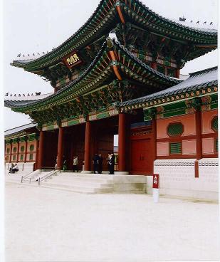
entrance gateway at Gyeongbok palace showing most of these features:
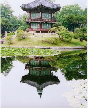
And here is a nice pagoda-in-a-lake, also at Gyeongbok palace:
As well as looking at some of the old palaces in the city centre
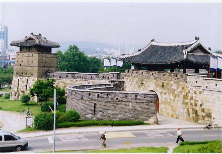
I've taken a couple of trips into the surrounding area. First I went
south to Suwon, a city with a UNESCO-listed wall around it. It was built
in the 1790s and restored in the last couple of decades. It follows
natural high ground for much of the way and is quite scenic, with
big gates, watchtowers and even a river-gate.
Then I spent an afternoon hiking in the Bukansan national park,
which is just North of the city centre. There aren't many cities in the
world that have 800m mountains so easily accessible. A bus can take
you to the park entrances from where paths lead up onto the peaks.
Most of the ground is wooded with granite outcrops on the tops. Sadly
there isn't much of a view as there is a lot of "fog" (i.e. air
pollution). There are lots of Korean hikers and I have much respect
for them having seem the sometimes quite scrambly routes that they
were tackling. I'm looking forward to seeing some more mountanins
further afield this week.
Hikers need maps and, unlike plenty of other places I've been to,
there are lots of good maps readily available here. But apart from the
needs of hikers
there may be another reason: it is impossible to find your way around
without one! The streets don't really have names and instead addresses give a
neighbourhood name (a few blocks) and a building plot number. These
numbers are allocated when the buildings are built so are not in any
useful order. So you really need a good map with a large scale (Seoul
street atlases have a scale of 1:5,000) that shows these numbers in order
to find anywhere. A side-effect is that unless you can't expect a taxi
driver to find somewhere given only the address. I thought that
Costa Rica had a disfunctional system - they have few street name signs
and no numbers - but this is much worse. Anyway it means that the
maps are good and, for example, every metro station has a good map of
the surrounding area (only problem: North is probably not at the top)
as well as a 3-D map of the station itself.
So I'm planning to see some more of the country now, probably
heading down to Chirisan mountain national park in the south later
in the week. But first I have to find some suitable camping food!
28 June 2003: Busan, Korea
I've just survived a couple of days in Jirisan national park,
and managed to get to the top of mainland South Korea's highest peak.
It has been a very mixed experience with some high-points and some
low-points. Korea is a strange country, perhaps the strangest that
I've visited.
Namwon
I took the train from Seoul down to Namwon, the nearest town to
the West side of the national park. The train was cheap, reasonably
fast and on time - South Korea is a definitely a contender for the trip's
"Best Public Transport" prize. Then I had to find somewhere to stay. A
chap in the tourist information booth at the station directed me to
the "tourist area" where, with the help of a young lady from another
tourist information booth, I found what looked like a respectable
and fair-priced hotel room. (Another great thing about Korea: unlike
almost everywhere that I've been, they have the same idea of Tourist
Information as we do in Britain. Not the tour operators passing
themselves off as tourist information offices that almost all of the
rest of the world has.)
So my room had what looked at first glance like a conventional
bed. This was a good sign, I thought, as in some of the cheaper places
you have to sleep on the floor. But then I took a closer look. On top
of the slightly-more-sturdy-than-usual bed base there was no matress,
but in its place a massive great slab of marble!!!!! Rock hard,
literally.
Just as I was recovering from that discovery I got a knock at my
door. It was the young lady from the tourist office, come to ask me
to come to dinner with her and her family. How kind! Such contrasts
between the totally ghastly (more of them to come) and the wonderful.
Anyway we had a pleasant traditional Korean meal - rice and various
dishes including copious gimchi, fermented raw vegetables with chilli.
And then she took me out to see the sights of Namwon. It seems that
a famous legend involving a young woman whose lover saves her from
the evil local lord is set here, and there are various shrines and
the like at which one can pray for (a) getting a man, (b) keeping your
man, and (c) having a son. (More of (c) in a moment.) So we took
in the shrines, I failed to throw a coin into the pot that plays a
tune hence failing to be granted any wishes, saw a traditional old
Korean village complete with loom, and then saw a totally untraditional
new Korean laser show and synchronised-music-fountain-contraption.
Luckily the chicken pedaloes were closed for the evening. A lovely
evening.
An aside: apparently for every 1 woman of "peak marriage age" in Korea
there are 1.28 men. That's an incredible discrepancy, and it's attributed
to selective abortion of female foetuses. Couples must have a son and
don't want more than two children. I estimate from that that 42% of
couples would be willing to abort a second healthy female foetus -
a really chilling number. Whether this is still going on I don't
know. Perhaps things have changed since the 70s and 80s when the
current generation of "peak marriage age" were born. I hope so.
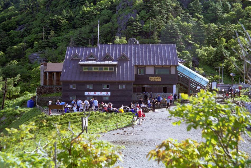
Jirisan National Park
I took a bus from Namwon to the national park and set off up the
mountain. It was quite a hike from the bus stop at about 600m to the
ridge at 1650m, especially with a bag full of camping stuff. But the
path was quite good, all of it in the trees, and I did it in about
4.5 hours. At the top there is a big hut, very much like the ones you
would find in the Alps or elsewhere in the world, and quite inexpensive:
I was the only non-Korean on the mountain. There were at least
a couple of hundred people spending the night up there, but I was the
only foreigner. Many of them were in big groups (I counted 80 in one)
with others in parties of half a dozen or so. I was befriended by
a medical professor from a local university, there with a few of his
students. (Interestingly, it is normally the older people like this
man who speak reasonable English. The students with him will undoubtedly
have spent a long time learning English at school, but are unable to
actually use it in practice. The professor, presumably having travelled
abroad, can manage a good conversation.) They were sharing their
food and drink with me and generally being very friendly.
"Lights Out" was at about nine and we retired to our sleeping spaces
- very much on the small side compared to similar places that I've stayed,
but a bit wider than my thermarest. The Koreans, used to sleeping on
rock hard surfaces, had brought neither mats nor sleeping bags with them,
content to sleep wrapped between a couple of blankets. It was to be
more than five hours before I got any sleep. The man on one side of me
played music from his personal MP3 player for the first hour or so, not
through earphones but through speakers. He subsequently edged into my
space - not entirely his fault as the next man along was getting
progressively more diagonal. My neighbour on the other side seemed to
fall asleep quickly, but kept thrashing about with his limbs. I got
his elbow in my ear - or worse - every half and hour or so. And the
snorring! I have observed that snorring seems worse in the Northern
hemishpere than the Southern. I can't think why but it seems to be
true - I was never disturbed by snorring in Patagonia, New Zealand or
Australia. I must have finally fallen asleep after 2, but was woken up
at 2:50 by the first people getting up! (Presumably they wanted to
see the sunrise at 5:15, and needed two hours to prepare themselves.)
It was quiet again by 4 and the music-man had gone, so I slept for
probably an hour and a half until the rest stirred at about 6. I
got a few more minutes sleep then until, a little before 8 and as I
was hoping that I'd finally be able to get some rest, the radio was
turned on. AAARRGGHHHH!
I had been planning to spend a few days at the top but after this
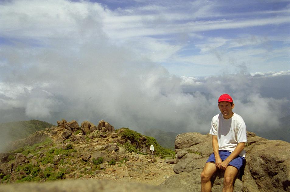
nightmare I couldn't face any more. So I walked to the summit and back
(not a bad view) and then set off down the other side of the mountain.
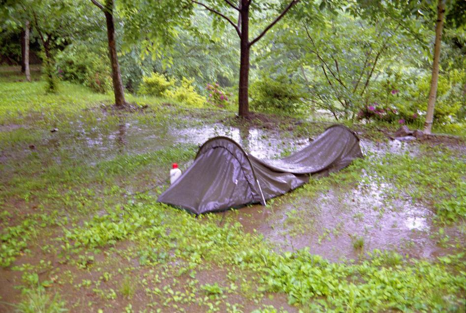
At the bottom I put up my tent in the campsite and finally started to
catch up on my sleep. I slept from about 7PM until exactly 3:22AM when
I was woken up by
the noise of the rain. Not a problem: my tent is waterproof, especially
since I seam-sealed it in Australia. But I now realise that the
lovely terraced campsite (which I had entirely to myself!) was probably
an old rice-growing terrace, and designed to retain any rain that falls
on it! So by 8 in the morning the water was about an inch deep
all around. I was still dry inside of course, but things got a bit
damp as I packed up.
So that was the end of my visit to Jirisan. I took a couple of
(fast, cheap, excellent) buses from the foot of the mountain to here,
Busan, Korea's second city and one of the world's largest ports.
You'll have to wait until next time to read more about what I've
found here, but I'll tell you now that the second language
here is Russian!
11 July 2003: Stockholm, Sweden
I'm now in Sweden and have Mike and Cia's PC to abuse for a while,
so finally I have the chance to write up what I've been doing for the last
few weeks in more detail than my last effort.
First, the last bit of Korea.
Busan
After my wet morning at the foot of Jirisan I went by bus to Busan,
Korea's second city. It's a big port in the south east corner of the country,
facing Japan, and if you're looking for it on a map it may be called
Pusan. A couple of years ago the South Korean government decided to change
their romanisation scheme; the new one is simpler, but less phonetic, and
in particular the first letters of lots of place names have changed, which
can make things difficult for a traveller.
I checked into quite a nice hotel with a real bed and more importantly
enough space in the bathroom to
hang up all my wet stuff. And a free newspaper provided exactly what I needed
to dry out my boots. After some of the places that I've visited previously
it was nice to see that this Korean hotel had fire extinguishers and even a
torch and smoke hoods in the wardrobe. As a final touch there was an
emergency escape rope thing above the window (which I suspect may save
fewer lives than are lost to idiots playing with it!) Or was all of this
just because I was in room 911?
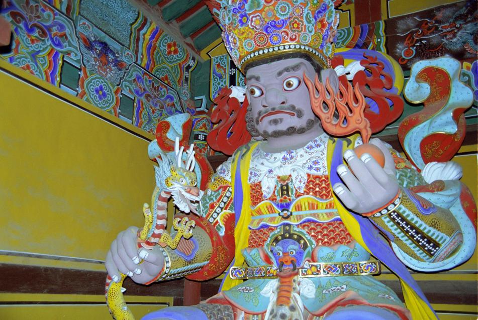
As it was still raining I decided against visiting Busan's famous
beach, but did go to their famous Budhist temple, Beomeosa. It has
essentially the same architectural style as the historic (and reconstructed)
buildings in Seoul, with a few more Budhist touches thrown in. Here is
one of the "temple guardians" in the gate house:
Gyeoungju and Gungju
The weather was getting a bit better but not exactly sunny, so I
decided to visit the historical city of Gyeoungju rather than any more
national parks. Gyeongju was the capital of the Silla kingdom which
was around for approximately the whole of the first millenium of the
Christian callendar.
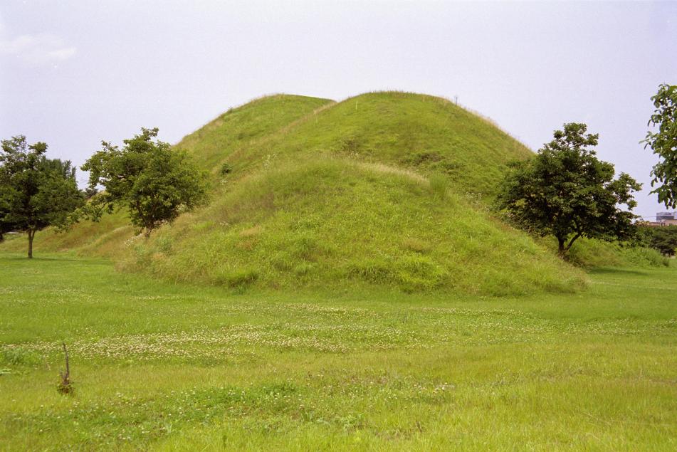
The most distinctive features of the town are the ancient tombs
that are right in the middle of the urban area. They are big tumulii
quite reminiscent of ancient British sites, but more reminiscent of Tellytubbieland:
Some (most?) of them have been excavated and one is now hollowed-out
so you can see how the things that they found were organised inside.
But you have to visit the museum to see the best of the artifacts,
which include some great gold crowns and other ornaments, bronze and
iron tools and weapons, ceramics and so on. The museum also has a
spectacular huge bronze bell dating back to 700 or so.
The museum's web site is at http://gyeongju.museum.go.kr/.
I then climbed Namsam, a big hill to the south of the town that
is supposedly full of buddhas carved into the rocks and the like.
Unfortunately you can't expect to find much if you just follow your
nose as I did - you really need to follow a guided route or have GPS
coordinates for the places of interest! But it was a pleasant walk
anyway.
Outside the town there is another Budhist temple, Bulguksa, which
is supposed to be one of the best in the country. It was built in the
early 1970s as a scheme of the then president. The (entirely
predictable) story is that a temple had existed there centuries before
and been destroyed by the Japanese, leaving only a few stone foundations
and some steps. It is quite pleasant though not worth quite as much
fuss as they make about it. The bit that I liked most about both this
temple and Beomeosa was the entrance structure with the four temple
guardians, huge carved wooden figures carying various symbolic items.
I've found a good web site with lots of stuff about asian architecture:
http://www.orientalarchitecture.com/.
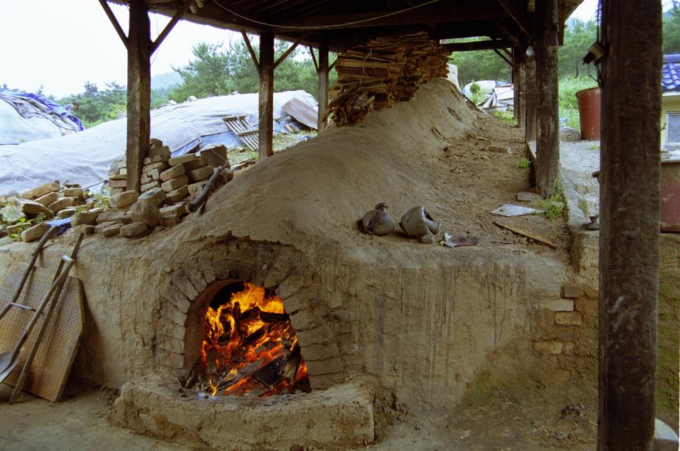
My final stop in Gyeongju was a handicrafts village, where
unfortunately the museum of Silla-era technology was closed due to a power
cut. But the shops were all still open selling mostly ceramics and a few
bits of embroidery and jewelery. Most interesting was a pottery where
they were using a reconstructed Silla-era kiln to fire the pots; it is
a sloping tube running up the hillside at about 45 degrees with a wood
fire at the bottom, chimney at the top and pottery being fired in the
middle.
Then, to break my journey back to Seoul, I stopped off in another
historical town, Gongju. This was also a capital, this time of the
Baekje kingdom, which I think co-existed with the Sillas over in
Gyeongju. They also have a museum with some really excellent artifacts
from an excavated royal tomb.
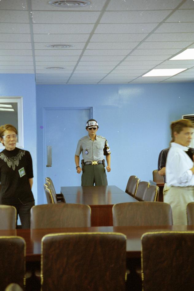
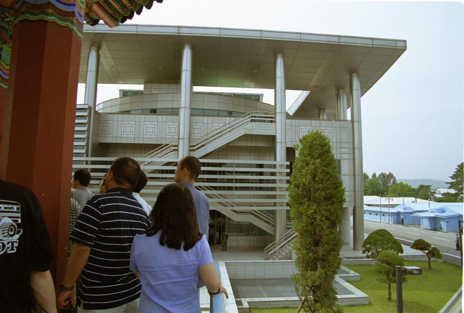
Panmunjom
Then it was back to Seoul for one last excursion before leaving
the country - a visit to Panmunjom, the famous point on the border
between North and South were the two sides face each other over a table with
the border running down the middle. It's an extraordinary place.
First stop, well before the border, was at a large building
on the top of a hill from where you might see a view into the North if
the visibility is good enough (it wasn't when I was there). It also has
some small
exhibitions of North Korean factory products and school textbooks.
The textbooks would be quite interesting if you could read Korean. The
English book was printed on ghastly paper and the excerpts were about
Kim Il Song, but the language was fine. And one of the maths books
seemed to be about writing programs to solve equations in BASIC,
which I suspect is not too much different from the rest of the world.
This place is called the "Unification Observatory" - a ridiculous name,
as in fact what you get to observe is the extreme disunity.
The ceasefire line from the end of the war in 1953 is flanked by
2km of demilitarised ground on each side with no way across, except at
Panmunjom. This has turned it into something of an oasis for wildlife,
but that doesn't seem to excite anyone very much. A road
takes buses of foreign tourists to Camp Bonifas, the "United Nations"
(actually U.S. and Korean) base, and from there through the fences and
minefields and then the demilitarised zone ("DMZ") to Panmunjom. You
get to see the "bridge of no return" where prisonners of war were exchanged
at the end of the war and the single-storey buildings - sheds really -
that actually span the border where intergovernmental talks are
sometimes held. It doesn't take long and in my mind it raised as many
questions as it answers.
If you visited the North side of the border - which you can - you
would expect a propoganda trip. I wasn't sure what to expect from the South.
It turned out to be reasonably factual, but you have to stay alert to
the spin that the guides put on what they're telling you. They are
South Koreans (or Americans) and give their side of the story.
Here are some of the unanswered questions that I had:
* These trips are only really for foreigners. If a Korean wants to go
they have to be vetted by the security services first, and a whole family
can't go in one group. "Why?", I asked. "To make sure that they don't try
to cross to the North", was the reply. So South Koreans aren't free to
leave their country if their government doesn't want them to.
* Although today it's clear that anyone in their right mind would
prefer to live under the regime in the South than in the North, people
forget that for the
majority of the 50 years since the war both sides have lived under
dictatorships.
* The United States cites this border as the reason why it still needs
mines and won't ratify the Anti-Personnel Mine Convention banning them.
This allows generalissimos around the world to say "why should I stop
using mines? - look, even the world's most powerful country still needs
them". Having just visited Cambodia where there are plenty of people
who can testify to the effect that mines have on the post-war civilian
population, I would like to know what efforts the South Koreans and their
American friends have put into finding an alternative to mines to defend
their border.
* Does either side want an end to the conflict at all?
Are they actually trying to be
friendly or are they antagonising each other? The impression that I get
is the latter. There are plenty of examples. In the vicinity of the
conference room there are South Korean guards who stand in a bizzare
frozen posture with clenched firsts by their sides, eyes hidden behind
dark sunglasses. It is apparently something to do with taekwondo. I
asked why they stand with this pose. The answer, according to the guide,
is "to intimidate the North Koreans". My next question, "Why do they want
to intimidate the North Koreans?", she could not answer. Korea has a
Budhist background. Wouldn't it be better to have some monks singing a
nice contemplative peace-and-love chant over the border? Then there's the
mine's-bigger-than-yours architecture over the border. The North had
the world's biggest flagpole. So the South built one a hundred metres
tall. So the North have built one a hundred a sixty metres tall. Then
there are the buildings behind the cross-border sheds on either side.
The boss of Hyundai has in the last few years paid for a huge new
concrete-and-glass-and-chrome thing to be built on the South side. The
North have a place that probably looked quite respectable until it was
faced with this new edifice, but now they've built an extra storey on
the top. It seems to me that whatever the people of South Korea as a
whole think, the politicians and military characters who run this place
see their role as maintaining the antagonism, not building trust,
friendship and peace.
Here are some photos. First, the inside of one of the meeting rooms.
The border line goes down the middle of the table in the foreground. The
action man at the other end is a South Korean martial-arts soldier to
"protect" us from the North Koreans. Note the "intimidating" pose and
dark glasses:
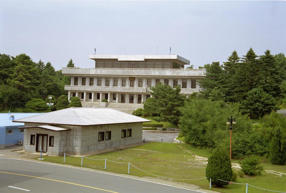
The is the North Koreans' frontier building. Originally it had only two
floors and the South had something similar.
Then the South Koreans built this huge edifice (actually built by the
founder of Hyundai). The North Koreans replied by adding the smaller top
floor to their building.
News about Finland and Sweden to follow.