Canada
6 August 2002: Montreal, Canada
Quebec
Here are a few quick words about what I've been up to during my first
week here in Canada.
I flew in to Montreal and spent the next couple of days travelling north
eastwards down the St Lawrence, stopping first at Quebec City. It's located
on a rocky outcrop looking over the river and its strategic position gave it
an important rule during the English/French conflicts; it claims to be
North America's only walled city. It's also the lowest point where the
St Lawrence is bridged. It was a very pleasant place to spend a day.
Mont Jacques Cartier
Then I carried on to Ste-Anne-des-Monts, on the South East side of the
St Lawrence where it's about 50 miles wide. There's not much to see in the
town, but the hostel provides free transport twice a week up to the Parc
de la Gaspesie. This is home to what I think is Quebec's highest mountain
- I can't find anything higher on the map, but there could be something
up in the arctic. It's Mont Jacques Cartier and it's 1270m high. (There
are lots of Jacques Cartier things in Quebec - he was the first European
to expore here.) The range is called the "Monts Chic-Choc" and it's the
northern end of the Appalacian range. Most of
the area is heavily wooded, with just the summits sticking out above the
tree line.
A national park warden on the summit gave an interesting talk about
the geology, fauna and flora etc. I'm not finding Quebecoise particularly
easy to understand. It really sounded as if this guy was telling us that
the trees were short because there was "trop de vin" - he was saying
"vent", but that's not what it sounded like to me!
It was warm and sunny on Mont Jacques Cartier, and the next day I
climbed its neighbour, Mont Albert. As I was leaving it started to rain, but
I still got a lift down to the bus station with a couple of French geologists
(thanks!).
Then it was on to Ottawa, Canada's capital, where I saw all the
landmarks and went to the Museum of Civilization, which is excellent.
It features a huge gallery full of totem poles and native houses, and
a gallery tracing Canada's history with recreations of buildings. Then
the current special exhibition was about the Vikings - very topical since
I've just arrived from Iceland!
Now I'm in Montreal, staying with my friend Alan, and have spent today
doing a bike tour of the city. WARNING: bikes here have the brakes the
opposite way around to British ones!
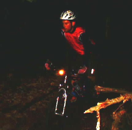
Mountain Biking at Night
Alan took me on an evening mountain bike trip with a group of his
friends on a nearby wooded hillside. The first uphill bits were somewhat
knackering but once I'd got over that it was very enjoyable. Here is a
picture that Alan took with a digital camera:
19 August 2002: Banff, Canada
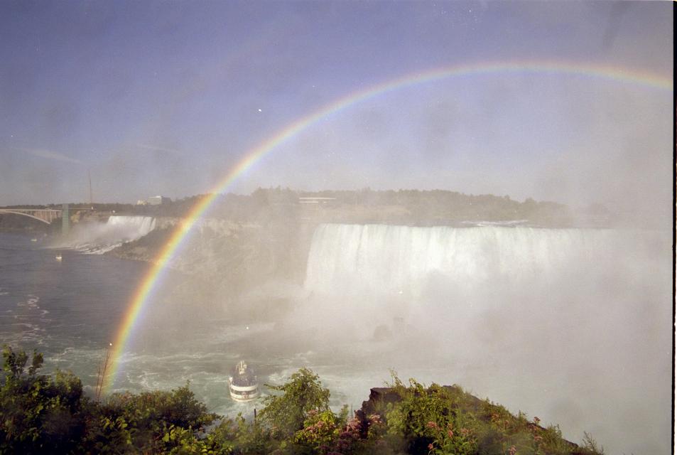
Niagara Falls
After a few days with Alan (and his cats, and his other temporary
flatmate - it was quite a housefull), I went to Toronto and
stayed with Craig (ex. AMULET) and his wife and five-month-old son (and
cat - though not quite as hairy as Alan's). Son Luke obviously keeps
Craig and Sandra fully occupied, but Craig and I did find time to catch
up over a couple of beers in his neighbourhood Irish pub. Then I took
myslef to Niagara Falls for the day.
I had been preparing myself for a tourist hotspot and Craig
wwarned me that it is Canada's answer to Blackpool, but I was pleasantly
surprised. I think that the sheer scale of the falls - ten times the
water-volume of Iceland's Dettifoss falling about the same distance -
dwarfs any human constructions on the banks. It was a sunny day and
there were rainbows everywhere. Very picturesque.
Next I took a train to Chicago. Don't ask why.
So I got to spend thirteen hours on a train. I will write more about
this once I have no need to pass through a U.S. frontier EVER AGAIN.
On the U.S. side of the border the train was full of crazies
who will "never get on a plane again". Aarggh. Then Chicago and a night
in a "Quality Inn" that seemed to be an integral part of an eight-lane
motorway junction. Anyway thankfully I am
now back in lovely Canada.
The Rockies - Banff
I've now been in Banff for nearly a week and have done embarassingly
little! Getting out of my tent early enough in the morning to climb a
mountain is the problem. Anyway, I did manage this one-and-a-half times.
I got to the top of Mount Rundle, a 2948m peak that overlooks the town.
(Banff is at about 1400m, so that's about 1550m of ascent.)
It was a fairly gentle,
but long, plod through trees, followed by some loose scree to the ridge,
then an easy scramble along to the actual summit. Other people had been
turning back due to cloud, but I pressed on and from the top had views over
the cloud to other peaks in the distance. Mount Assiniboine (?) is a
spectacular (and hard) Matterhorn-like peak that dominates the view.
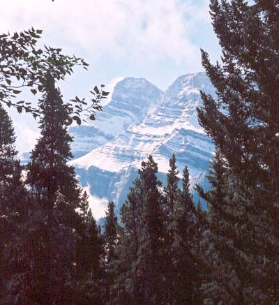
The following morning, snow had fallen: here's the view of Mt
Rundle from the campsite.
The "half" was Mount Bourgeau. I set off late and walked up to some
lovely corrie lakes and then up to a pass at about 2500m from where there
was a view, but mostly of approaching rainclouds, so I called it a day.
In an effort to climb some more of these lovely peaks (and they really
are very beautifull) I'm going to Mosquito Creek hostel next, where I hope
staying in bed too long will be harder! I fancy Observation Peak, which has
views out over one of the icefields and has a nice high-altitude start.
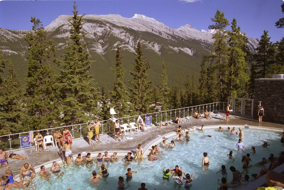
Of course there are other things to do in Banff. I've walked most of
the valley trails, and this afternoon went to the hot springs. It's not
quite the same as Iceland but is a pleasant way to relax, and it has a
great view of Mt Rundle.
Afterwards I had
afternoon tea at the very exclusive Banff Springs Hotel with some people
I'd met on the mountain and bumped into again at the springs. The hotel
reminded me of Neuschwanstein Castle - enormous and faux-medieval!
So I'll be here for a while longer, so expect some more updates with
news of more peaks that I've climbed.
25 August 2002: Banff, Canada
I'm back in Banff. I wasn't really planning to be back here, but the
campsite in Lake Louise is closed (bears on the prowel!) and the hostel
is full, so I'm here for a night before moving on. But is does give me a
chance to keep all you eager friends and relatives up to date with my news.
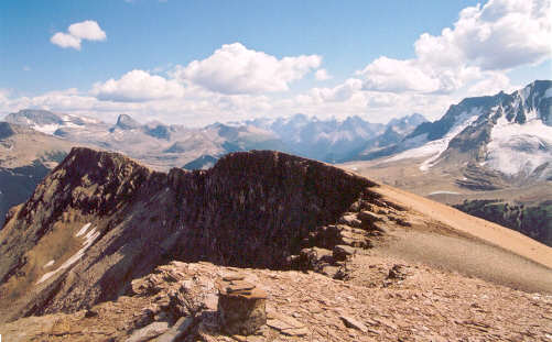
Mosquito Creek
Mosquito Creek hostel must be one of the world's few remaining "primitive"
hostels, with no mains water, electricity or drainage. They have UV-treated
stream water, pumped by a solar pump, gas lights and fridges, and a
wood-burning sauna! It's very rustic and pleasant, and full of all sorts of
interesting people. (Plus, as usual, a few uninteresting people who go to
bed late and make lots of noise.)
I was there for three nights and two days, and as predicited I did get
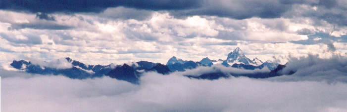
up early enough to do some proper walks. On the first day I climbed
Observation Peak, a thousand metres of mostly hard-work clambering up scree.
But it is certainly worth it, and I made plenty of stops during the ascent
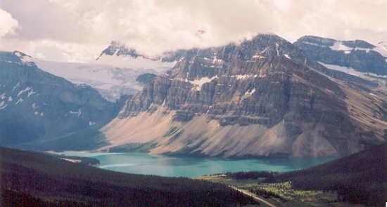
to look behind at the unfolding view. The starting point is the pass between
the Bow river (which flows South through Banff and Calgary) and something
else that flows North into the Sascatchewan and through Edmonton. These
rivers both flow from glaciers on the mountains opposite, and flow first into
lakes that are a bright turquoise colour because of the galcial material
that they are carrying. From Observation Peak these lakes, Bow Lake and
Peyto Lake, are almost mirror-images of each other to the left and right.
Behind them more and more snow-capped peaks became visible, and eventually
as I reached the top I could see not only the range opposite but higher peaks
in the range beyond. Most distinctive was the easily-recognised Mount
White-eaves. This picture is Bow Lake from about half-way up.
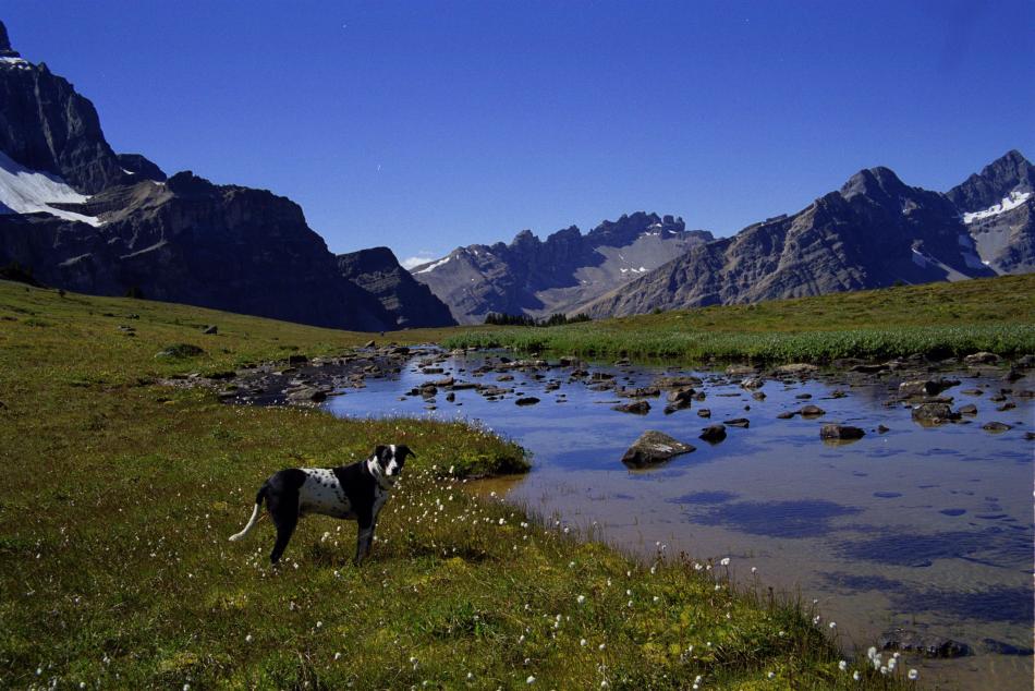
Then on the second day I took an easier option and just walked up
Mosquito Creek itself. This leads through the woods and eventually up to an
alpine meadow and lake before crossing a pass into another valley. But to
make the walk more memorable I was accompanied by Petzl, the hostel manager's
dog, who set a very good pace and knew exactly where he was going.
So although these mountains were impressive I knew that higher and
snowier ones could be found further North, and I set off for the Columbia
Icefield. I got a lift with another English guy from the hostel, and on
the way we stopped off at most of the touristy viewpoints. Here's another
view of Bow Lake:
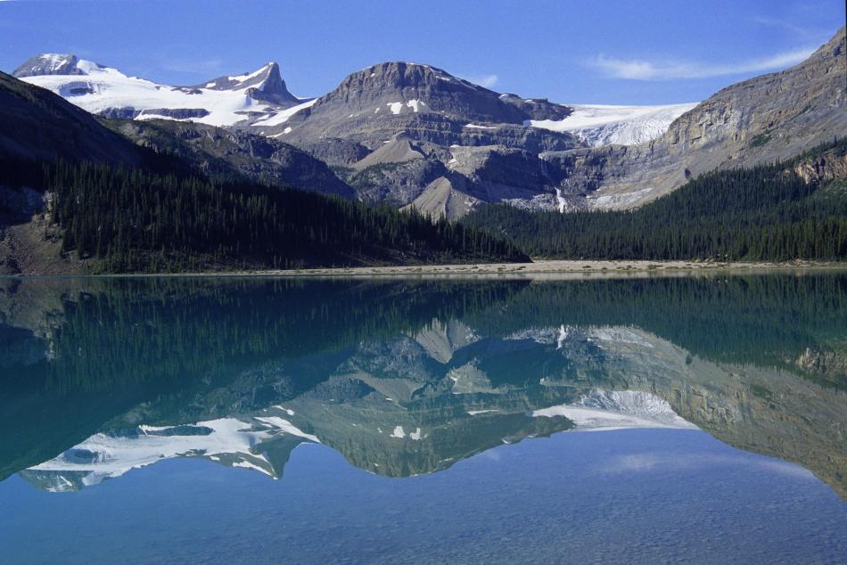
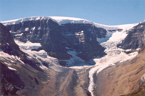
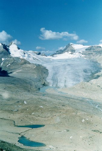
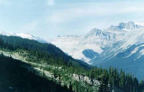
Columbia Icefield
It was back to my tent here as apparently the hostel burnt down! The
Columbia Icefield is a huge sea of ice from which several glaciers flow in
different directions. One of them, the Athabasca glacier, is right next to
the road and has been made accessible to "bus tour" tourists and others by
"sno-coach" tour. It's a bit of an eye-sore but at least it is only one of
them. The high point of the icefield, the Snow Dome, is significant
because from here ice flows three ways: North to the Arctic Ocean via the
McKenzie river, West to the Pacific, and East to the Atlantic via the
Sascachewan
river and Hudson Bay. For a properly-equiped group of more than one, getting
up onto the icefield would not be difficult, and the campsite was full of
people getting up before dawn to make glacial ascents. But you do need
someone to hold on to the end of the rope when you fall down a crevace, so
I satisfied myself with an ice-free ascent.
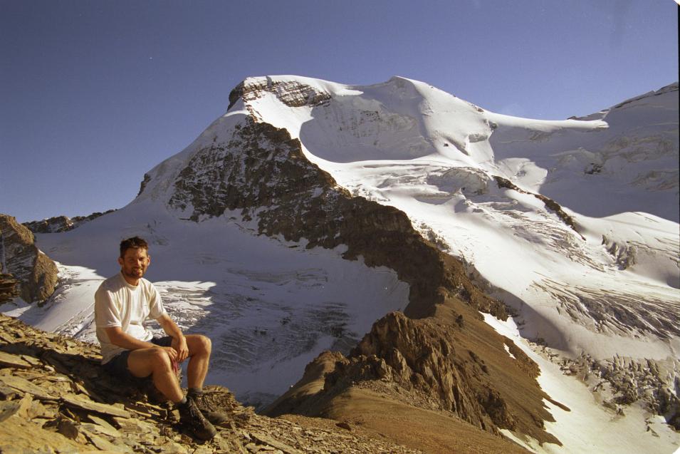
The peak I chose is not named on the map, but one of my guidebooks calls
it Boundary Peak because it lies on the boundary between Banff and Jasper
national parks. Like Observation Peak it is mostly toil up scree and
actually climbing up the glaciers would be far more pleasant. But the
ascent was well worth it for the excellent views. Right next door is
Mount Athabasca, a huge snow-capped peak with glaciers coming from all sides,
and next to it is the Snow Dome and Mount Kitchener. Then, in the distance
and visible in gaps between the others, are Mount Columbia, a 3700m monster,
and Mount Sascachewan, a peak with such an interesting shape that it gets
its picture on the banknotes (or so I am told). This picture is me in
front of Mt Athabasca.
And here is the Snow Dome:
My second day could not rival that, with just a bimble up to the
hill behind the campsite for one last look at the view. Now I'm back in
Banff for a night, and will be crossing into British Columbia to visit
Yoho National Park tomorrow.
3 September 2002: Vancouver, Canada
This may be a short entry. I am sat in an Internet Cafe
in Vancouver surrounded by teenagers and students who are
trying to kill each other. That's virtually kill each other,
of course, but it's pretty distracting. I should have brought
ear-plugs to mask the machine-gun fire and turret's syndrome
outbursts of the guy sat next to me. And the computer is
running a Chinese version of windows, which doesn't help.
Anyway I'll stop whinging now and tell you what I've been doing
for the last few weeks:
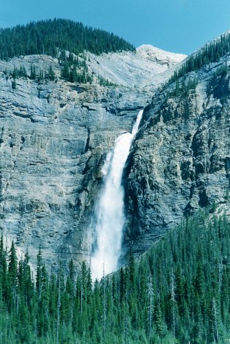
Yoho National Park
So I eventually made it over the border from Alberta into
British Columbia, and into the Yoho national park. I camped in
a site at the end of a minor road with a great view of
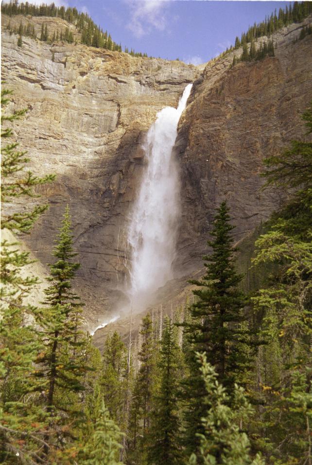
Takakkaw Falls - a spectacular 250m-high waterfall with a
"kick" at the top that sends the water out horizontally for
a bit. So I stayed there for three nights and did a couple
of good days hiking.
First I climbed Whaleback Mountain. A few miles away is
the Burgess Shale, a famous fossil site; the fossil-hunters
love that the rock splits apart slate-like, but it means that
the mountains can be like giant slate-mine spoil tips!
Anyway I found a path up Whaleback Mountain and got a good
panoramic view from the top. To the North, glaciers came
down from the same ice-cap that I'd been to the East of at
Mosquito Creek, but on this side, because they were
south-facing, they were "dry" rather than snow-covered.
To the South the view was dominated by The President and
The Vice President, two big mountains with snow-covered,
North-facing, glaciers hanging down from them. And
below on all sides the slopes dropped down into the trees
that fill all the valleys.
On my way down I took a detour (i.e. I slithered down
the horrible scree, rather than taking the path) in order
to see Twin Falls - another famous tall waterfall with,
as the name suggests, a pair of parallel falls.
Then on my second day I did a shorter walk, hiking
up to Little Yoho Lake and on to see the view of Emerald
Lake, a well-known local beauty spot. On the way back it's
possible to see the glacier that feeds Takakkaw falls.
Seattle and Victoria
So finally it was time to get on the Greyhound bus and
leave the rockies behind, and here I am in Vancouver
about to fly to Mexico for country number three. But first I
took a detour to Seattle to visit my friend Becky, who has
been living there for the last few years. The train from
Vancouver down to Seattle follows the coast, right along the
beach in places, and has excellent views, especially as the
sun was setting. Then looking inland I got a few brief
views of a mountain that was obviously a volcano - probably
Mount Baker, I am told.
Becky and her husband have just moved into a new place
and it's very pleasant. (I do get jealous of all these
youngsters who've got further up the home-comforts ladder
than me!) Anyway, we went out for a hike in the Cascades
with another English friend of hers; it wasn't a long walk,
and like most places around here unless you walk for hours
and hours you don't even get to the tree line and see no
real views! But it was pleasant nonetheless, and the lake
at the end of the walk could even have been warm enough to
swim in, except that it was raining!
For variety I took a different route back, going by
boat via Victoria on Vancouver Island. It was a bit misty
going up Puget Sound so I couldn't see the big mountains
in the distance, but the coastline is pleasant. And for
the second leg from Victoria back to Vancouver the route
was really very scenic as the ferry navigates through some
really very narrow straits between islands. (And the sun
was coming out by then!).
Victoria itself was an odd place; all the Canadians
say it's "very English". One guy told me that I would
find it like Blackpool or Bath - and since these two
English towns are about as different as they can get,
it's clear they don't have any idea what "very English"
means! It does have a nice Maritime Museum though.
So now it's nearly time to move on - Canada has
been fun and I can certainly recommend the Rockies to
anyone who wants something different from the Alps for
their next holiday. Now it's time to start exercising
my Spanish.
4 September 2002: Dallas Fort Worth Airport
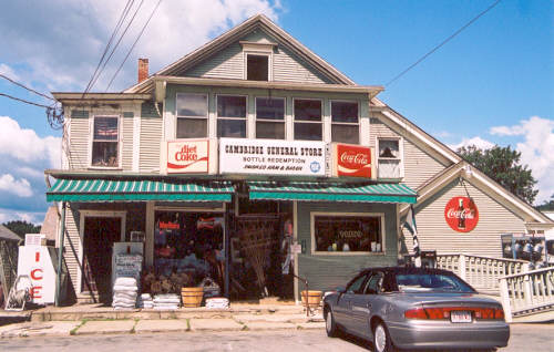
Cambridge, Vermont
I forgot to mention this before; when I was staying in Montreal
with Alan, we took a day trip over the border to Vermont and had a
look at Lake Champlain, Burlington, and the Smugglers' Gap pass. On
the way back, by chance we passed through Cambridge - a little place,
perhaps "small town America" typified. I hope you can read the
words on this picutre:
I'm just passing through Dallas airport on my way to Mexico, and
I've found an airport internet terminal that's actually useable! It
has a proper keyboard, and (for the tech-savvy) it does HTTP AUTH, which
most don't. Guess what - it's made by AT&T!
15 October 2002: San José, Costa Rica
Photos!
Dad has kindly scanned in some of the Canadian photos that I posted home.
This one is Takkakaw Falls, in Yoho national park.
This is a view of (I think) the Yoho Glacier -
certainly it is one of the glaciers at the top of the Yoho
valley - taken from Whaleback Mountain. I think it is the stream
that flows down to Twin Falls.
And this is a view from Yoho's Iceline Trail,
looking up the Yoho Valley from just above the treeline.
© 2002 - 2003