17 November 2002: Cusco, Peru
Subject: Peru
Ollantytambo
Having spent rather a long time in Cusco we had to go somewhere else, so we took a couple of buses to Ollantytambo, on the Urubamba river. Ollantytambo has some impressive Inca ruins above a small town which still has its Inca street plan (the only town to do so). Below the town, Inca agricultural terraces stretch down to the river.
Ollantytambo was the site of the Incas' penultimate stand against the spanish. A fairly small Spanish force was defeated at the steep stone terrace walls; apparently the Incas managed to divert the river to flood the ground at the foot of the walls up to the horses' bellies!
If you remember a "secrets of the ancients" TV documentary about Inca stone work, Ollantytambo is the place where they demonstrated how they may have moved the huge rocks from the hillside opposite, down to the valley, across the river and up to their final position. In the town I spotted the huge "tired stone" that had been sat in the corner of a square for a few hundred years and which they demonstrated could be dragged quite quickly over the cobbled road surface if you had enough people. (Of course you wouldn't know about any of this if you hadn't seen the TV programme: there is zero information for visitors at the site.)
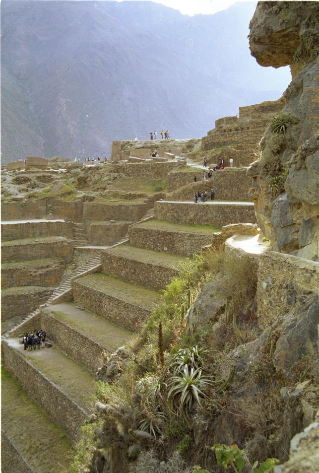
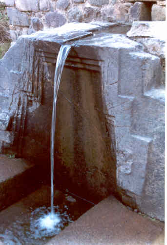
The ruins themselves consist of some tall agricultural terraces with lovely stonework, and a complex of temples and other buildings at the top. The temples looked uncompleted, with some huge pink stone blocks carefully fitted together but others left lying on their sides. Then there are some granaries: two-storey buildings built into the hillside so that grain can be tipped in at the top and removed from the bottom. Finally at the bottom a series of channels carved into the bedrock supply water to some "fountains" (really waterfalls) which could have had some sort of ritual cleansing function.
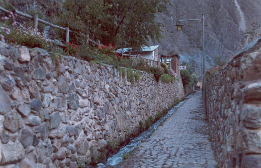
Later we walked around the town and climbed up to a vantage point from where we could see its Inca layout. It is built on a grid pattern with narrow lanes between high walls. The walls - built with typically-good Inca stonework - enclose whole blocks with just a single entrance. In many cases the tapering Inca doorways and lintels survive. Inside the enclosures contain houses and gardens with trees and crops such as maize. Also surviving since the Incas are water channels running down many of the streets, reminiscent of Wells or Hobson's Conduit in Cambridge.
Salinas
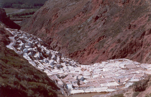
Between Ollantytambo and Urubamba a natural salt stream emerges from the hillside, and for hundreds or thousands of years they locals have been filling salt pans from it. It is very photogenic. They carry the salt away by mule.
The Inca Trail
The Incas built lots of roads and could famously send a message by runner from Cusco to Quito more quickly than the modern Peruvian postal service can manage it (though I hear that our first parcel full of stuff from Lima's craft markets has made it all the way to Dorset, so let's not be too down on them!). After the conquest, many of the roads continued to be used and worn out, but the more difficult ones up in the mountains that were impassable to horses and carts fell into disuse and became overgrown.
One such trail was rediscovered by the expeditions led by Hirham Bingham and others that uncovered Machu Pichu. But in contrast to many of the other Inca roads it is believed by many that this trail was actually a pilgrimage route to Machu Pichu. (Compare it with the Christian pilgrim's roads to places like Santiago de Compostella or Canterbury in Europe, or to Muslim, Hindu or Budhist shrines in other parts of the world.) Today the last 40km of this trail, called "The Inca Trail", is a popular way to get to Machu Pichu.
The popularity of the trail has resulted in lots of regulation and paperwork. Most importantly you can now only do the trail as part of a group with an authorised leader. This cost us US$235, of which US$50 goes to the authorities and the rest pays for guides, porters and food. The trips are very luxurious: with more porters than clients we got excellent food served to us at a table with chairs and tablecloths. It's very different from any sort of hiking I've done before.
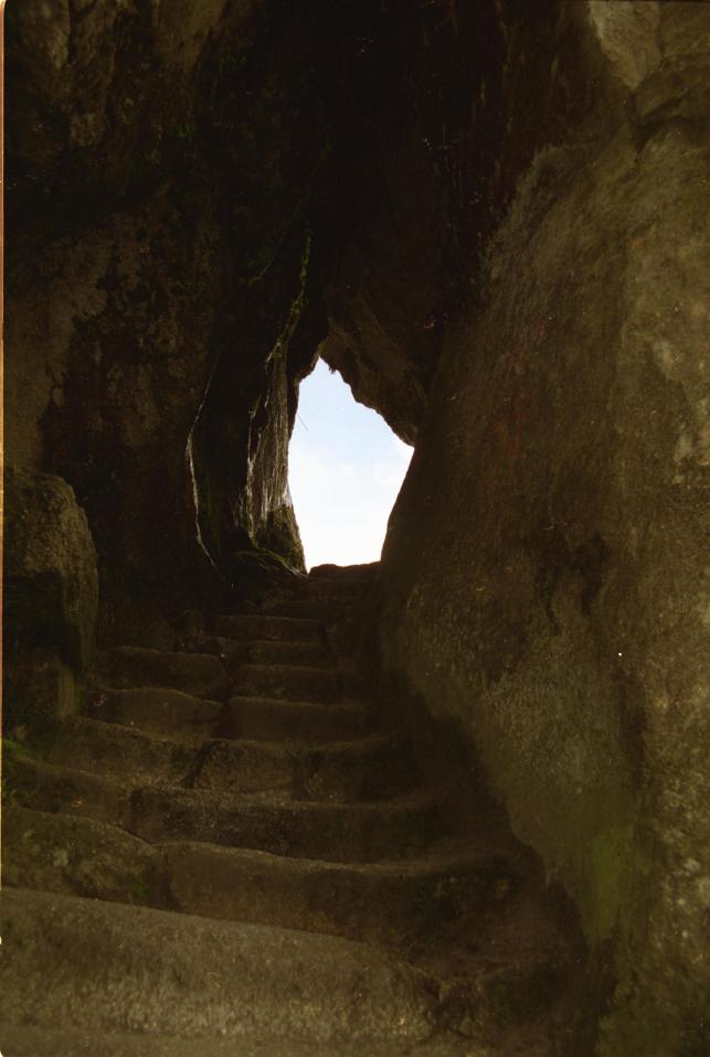
The actual walk is quite easy: day one is a short stroll to the first campsite; day two is more strenuous as it climbs about 1200m, but extra porters are available for anyone who can't manage their own bag and we had finished by lunchtime. (Having spent three weeks at more than 3000m up made this much easier for us than for those who'd just arrived from sea level.) Day three is longer but doesn't have much climbing, and day four is just a couple of hours to reach Machu Pichu in the morning. The paths are good all the way. At first it is a modern gravel surface, but after the pass on the second day it is mostly paved with lots of stone steps. One the whole it looks like modern paving on Inca foundations; to traverse the steep hillsides they built big retaining walls, like their agricultural terraces. But from time to time there was something undeniably original Inca, such as steps cut into the actual bedrock and sometimes even tunnels where they had enlarged a natural fissue.
The trail starts near the Urubamba river a few kilometers downstream from Ollantytambo. The river valley downstream narrows and twists and turns before eventually passing below Machu Pichu (it finally becomes a tributary of the Amazon). The trail, on the other hand, climbs up into the mountains and arrives at Machu Pichu from above! The classic postcard view of Machu Pichu is what Inca Trail hikers see when they arrive.
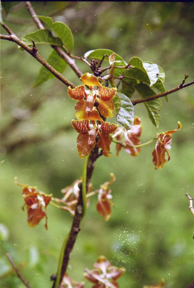
The natural history along the trail is interesting too. At the start the vegetation is dry with lots of cactus, agave and air plants. As it climbs it passes through some cloud forest, and then above the tree line the terrain is open and not unlike British uplands (the drizzly weather we had at the time added to this impression). Then down the other side the trees return and are more tropical, with lots of ferns, begonias (including a very bright neon orange one) and orchids. We saw about four different orchids. I spotted the really obvious pink one whose name translates as "always young" because it flowers throughout the year. (Sadly the first flower we found was a freshly picked-and-discarded flowerhead; we later found a big clump of stems, more than a metre high, all but one of which had had their flowers picked.) Christine's better-trained eyes also spotted the more subtle brown-yellow-green flowers; one had a flower spike the size and shape of a fern frond, made up of hundreds of little flowers. Another had mostly-borwn flowers about an inch across on a winding climbing stem. Although we had seen plenty of nice orchids in Monteverde's orchid garden it was nice to finally see some in the wild.
We didn't see much in the way of fauna, apart from a few hummingbirds (in spanish called piqueaflores, flower-pickers) and some other little brown jobs. But another couple in our group were lucky enough to see a family of spectacled bears near Machu Pichu. We were jealous!
There are various Inca ruins along the way which provide good places to take a rest. The suggestion is that they could be Tambos, which means something like inns where travellers or the famous postal runners would stop. But they also contain some high-quality structures suggesting ritual significance, as you might expect on a pilgrimage route, and possible defensive features. (The Incas had only conquered this Amazon region a short time before the conquest, so it was still frontier country.) One particular ruin, whose name temporarily escapes me, was especially nice. Its water supply had been reconstructed: a leat along the hillside brought spring water into the site over a grooved-log aqueduct, from where it flowed through channels carved into the rock to a series of fountains. Also, at this particular site the cracks in the (not-highest-quality) stonework were full of tiny plants. Lovely. But of course nothing compares to the remains at Machu Pichu.
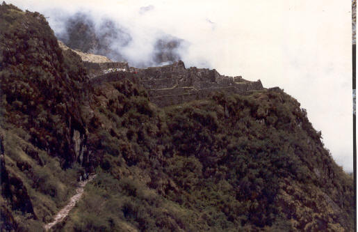
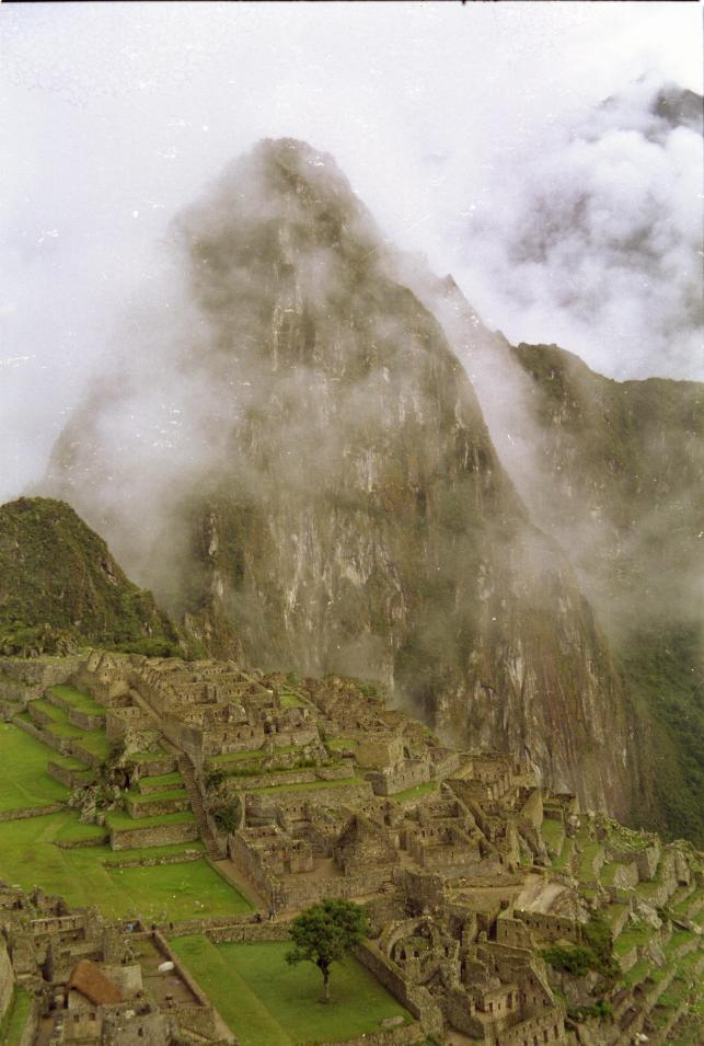
Machu Pichu
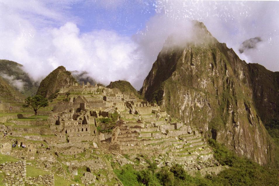
So, we've been to probably the second best known archaeological site in the world (I suppose that the Pyramids have to get first place). Certainly the image of an expanse of stone buildings on a high mountain saddle surrounded by tropical jungle is an icon for the Inca civilisation, and probably adorns more than half of the postcards that are sent home from Peru. And it is certainly worth seeing. Here are a couple of my pictures (extra-large since they are rather special).
First the gripes: the US$50 that we paid to get in wasn't enough to include the toilets, and they have nowhere you can buy a guidebook or even a postcard. And our guide - included in the Inca Trail package - was useless! But armed with our trusty "Exploring Cusco" book we did our own tour.
Arriving from the Inca Trail you first pass through an area of agricultural terraces. These are separated from the "urban" area by a water course where rock channels supply a series of ten fountains whose construction quality - and presumably also the water quality - is best at the top and most rustic at the bottom. Above this is the "sun temple", a structure constructed from high-quality stonework with some sort of astronomical / calendarical function. One of the windows has some extra carvings which it is suggested could have held a wooden thing to cast shadows on a carved rock inside. From here there are further high-class buildings along the top of the hill, looking down over terraces dropping down to the river Urubamba at an angle of 80 degrees. These are separated from the more utilitarian buildings by a relatively flat grassed area grazed by llamas and alpacas. Then there's an area with two open-sided buildings facing onto a square which it is suggested could have been some sort of performance area. Along one of the other sides is a large upright flat rock with a small raised "stage" in front of it; the rock could be acoustically useful, but also relects the outline of a mountain visible behind it.
From here we took a steep trail to the top of the adjacent mountain (this is the one in the background in the classic views of Machu Pichu). And it certainly is steep, with the steepest steps and smallest tunnels of anything we've done. At the top are a few buildings and a good view down onto the main site. There are also some incedibly steep terraces: it is suggested that they are too impractical for normal agriculture, so perhaps they could have been planted with bright flowers to add a splash of colour to the view from below. It's pure speculation (unless someone does a pollen analysis) but it's a nice idea!
Back in the main site we wandered around the utilirarian half of the buildings, which included some odd underground grottoes and some round things on the floors that could have been querns. And that was about it.
We walked down to the river - about 400 vertical meters down I think - through increasingly tropical forest with pretty plantanilla flower spikes (banana-like things). Then after a late lunch it was time to take the train back to Cusco - a trainspotter's delight about which I may write more next time. Keep tuned for the next installment!