24 March 2003: Franz Joseph, New Zealand
Subject: New Zealand
Punakaiki and Mount Bovis
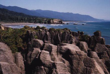
When I left Nelson I took a bus down the West coast and got off at a small place called Punakaiki. It's a popular place for a short stop to look at the "Pancake Rocks" - the limestone is oddly eroded by the sea and looks like stacks of pancakes! Amongst all these flat rocks there are a few blow-holes that could look interesting when the tide is in and the sea is rough.
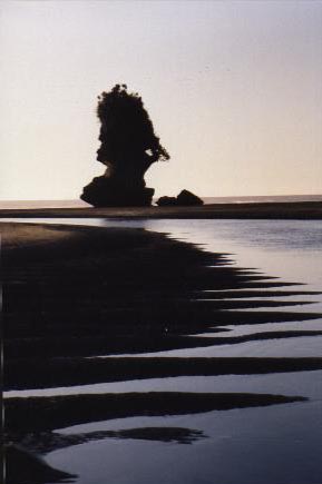
At the other end of Punakaiki beach there is some other spectacular erosion going on. How much longer will this stack last I wonder?
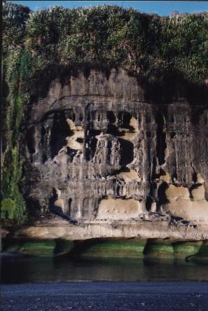
Then there is this odd cliff whose base is being cut back by a river reaching the sea, with a bright green algae band marking the high tide. I took these pictures just before sunset and everything looked very picturesque.
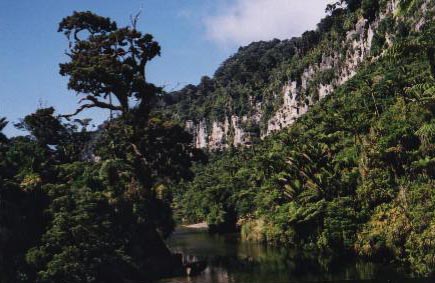
But I decided to stay for longer and see some more of the Paparoa National Park, of which the Pancake Rocks are just the most visited corner. Inland there is a range of 1000m-plus granite mountains, but between them and the sea there's a belt of limestone a few kilometers wide. So the water runs off the mountains and sinks into caves, to emerge later in classic steep-sided limestone canyons emptying into the sea. This is the Paparari river canyon where I started my walk:
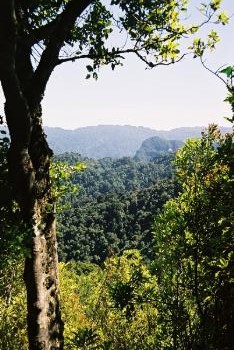
Apart from the very tops of the mountains, and a few areas cleared for farming, the whole landscape is quite densely forested. I spent one day walking inland on an old settlers' track, alongside a river through a canyon, and then pitched my tent in a clear area at the top of "Bullock Creek". An appropriate name as it turned out. Anyway, on day two I set off up Mount Bovis, a 1250-odd metre peak. It shouldn't have been too much of a struggle, but it took me ages. The first three or four hours were steeply uphill through the jungle on a hint of a path, climbing up staircases of tree roots and squeezing between giant ferns. All very tiring and not much view, and quite reminiscent of Middle Earth! Here is one of the few views that I got on the way up:
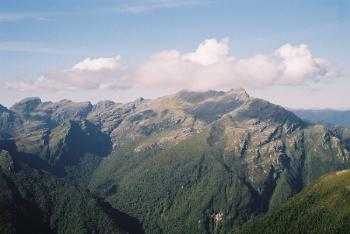
Eventually I emerged above the tree line and the top was in sight, and finally there was also a view of the other mountains in the vicinity. The highest were over 1400m; in a few places they were quite rocky, but mostly the ridges would be walkable. But I wasn't going to have time to go beyond the top of this peak.
Getting from the tree line to the top took another hour. It got quite scrambly at the end. Here is a view of some of the other Paparoa summits, most of which are named after famous scientists:
Then I had to do it all in reverse to get back down. I just about managed to get down before it got dark, which was certainly a good thing. (They mark the route with bits of white stuff like venitian blind material nailed to trees, and a few orange triangles which on close inspection turn out to be not quite eqilateral and are supposed to be arrows. But none of these glow in the dark!) Then came the excitement of getting back to my tent. As I walked along I could detect various large dark things out in the gloom and I suspected that they could be cows. Eventually it was really dark (there was no moon) and I got out my headtorch; the creatures were attracted by this and I was very grateful for the flimsy not-properly-shut gate between me and about a dozen pairs of glowing green bullock's eyes! I was actually quite petrified as I heard the "distant thunder" noise of their feet first and had no idea if they were going to stop.
Anyway I survived and the following morning walked back to the coast and got on a bus South to Greymouth, a largish town by West Coast standards that looks like it just survived the departure of the gold miners a hundred years ago! And after stocking up in its supermarket I made my way to Franz Joseph, capital of New Zealand's Helicopter Country (oh and it has a famous glacier). More about that later.