10 March 2003: Wellington, New Zealand
Subject: New Zealand
Rotorua
Rotorua is a major tourist centre in the North island because of its volcanic activity and maori cultural significance. I spent a day and a half there and visited two of the geothermal areas.
First I went to the Waimangu valley, which I chose because it had won all sorts of awards for environment-friendly tourism. The geothermal activity started in 1886 when Mt Tarawera errupted; it was a huge erruption with about two cubic kilometers of lava being ejected in less than four hours! The erruption was along a row of vents from the summit of the mountain into the surrounding countryside, and the Waimangu visitor attraction is in the valley of these vents. There are various hot springs, steaming lakes and water-filled explosion craters to look at.
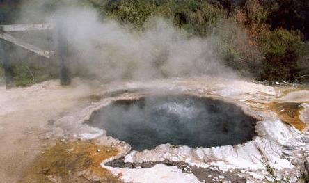
The second place I went to was the Whakarewarewa thermal area, which is on the outskits of the town of Rotorua and is looked after by the Maori Arts and Crafts Institute; there is also a traditional Maori village and intricately carved meeting house to look at. This hot pool was traditionally used for cooking:
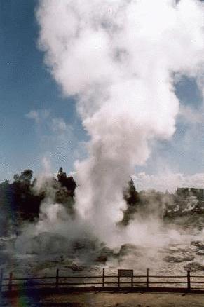
They have a couple of geysirs, and in fact these are the only active geysirs in New Zealand. This one seemed to be constantly ejecting lots of water and steam but I didn't see it errupting properly.
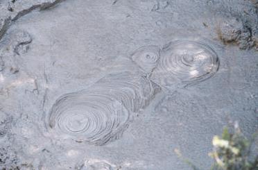
And of course there were lots of bubbling mud pools.
I didn't stay in Rotorua for long because the weather was good and I thought I ought to go and make the most of it while it lasted. So I set off to visit the Tongariro national park.
Tongariro
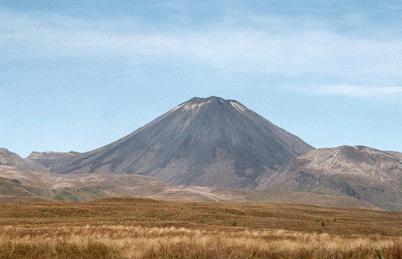
South of Rotorua, Tongariro is part of the same volcanic chain. There are three big volcanoes: Tongariro itself in the North, an old eroded mountain, then the incredibly new Ngaururhoe, and in the South the higher peak of Ruapehu, which catches most of the precipitation and has been developed as a ski centre. I spent three and a half days doing the Tongariro Northern Circuit, with side trips to the summit of Ngaururhoe and Tongariro's northern crater.
This is Ngaururhoe, 2291m high and only 2500 years old!
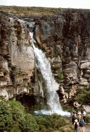
At the start of the circuit the path passes this impressive waterfall, Taranaki Falls, which make an easy day walk. There are fewer people on the path after this.
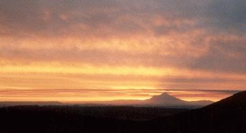
The first days's walk, to the hut at Mangatepopo, was very short. The huts on this walk are excellent; they have gas heating (not needed at this time of year) and stoves and matresses for a couple of dozen people. There was a spectacular sunset from the hut: the sun went behind Mount Taranaki, a dorment volcano to the South East.
Day two is the longest day, and a lot of people do it as a day walk - the so-called Tongariro Crossing. I took a side trip to the summit of Ngaururhoe, which involved a lot of three-steps-forward, two-slides-back to get up the slopes of very light pebbles. At the top you are rewarded with a sudden view down into the overhanging crater, which must be less than a hundred metres in diameter. It's not active and in fact there was a patch of snow in the bottom.
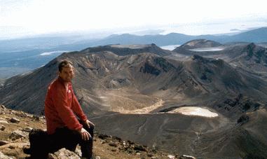
The view from the top was also well worth seeing. Here I am sat on the top. Behind me you can see the flat top of Tongariro's north summit, the Blue Lake and in the distance lakes Rotoaira and Taupo.
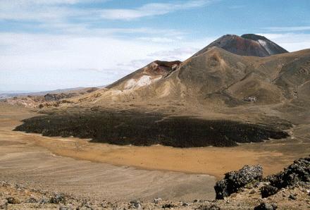
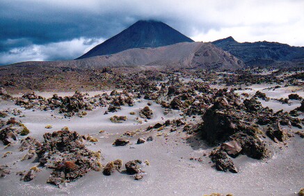
From Ngaururhoe the route heads North through a couple of dry, flat-bottomed "craters" that are actually glacial cirques rather than volcanic features. On the way you pass the Red Crater, an active crater from which sulphurous smells and steam emerge, and the Emerald Lakes, three small lakes coloured by minerals from the Red Crater.
Here is a view looking back to Ngaururhoe later in the day. In the center is the Red Crater, from which the black lava flow in the foreground must have come quite recently.
The day finished at another excellend hut with a view Northwards over lakes Rotoaira and Taupo. I had been the only person in the hut at Mangetepopo, but at this one there were about a dozen of us, including a group of four desperately ill-prepared english lads. They had brought no cooking or eating things so they were constantly borrowing from the rest of us, and were hoping that their four litre bottle of fresh milk would last, unrefrigerated, for the three day walk! And I think only two of them actually had sleeping bags!
The next day I climbed back up the seemingly-unending zig-zags above the hut and then up to Tongariro's northern summit. This is a very large, flat, round summit whose geological origin is fascinating. At some point Mt Tongariro had a summit crater lake of molten magma which slowly cooled and solidified into hard basalt. During subsequent glaciation much of the rest of the volcano, made from softer material, was eroded away. Now all that is left is the flat surface of what was once the molten lake. (You can see it in the self-photo from Mt Ngauruhoe above.)
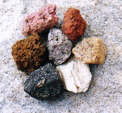
There are lots of different kinds of rock here. I collected these seven different colours on the slopes of the northern summit.
I spent the afternoon descending the East side of the mountain to the next hut. This side of the masif must get relatively little rain and the terrain is quite desert-like, with old lava flows and lots of ash and sand.
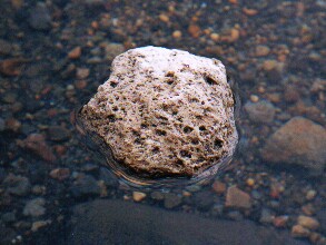
Pumice is one very common rock here; an erruption at Taupo in 186 A.D. ejected many cubic kilometers of the stuff which forms a layer up to several metres thick over much of the area. There was some very similar stuff at Askja in Iceland (the place where I swam in the crater lake) which apparently was found as far afield as Stockholm. Anyway here is a big lump of it floating in a pool:
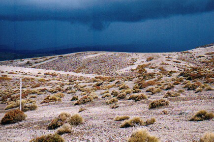
Later on clumps of vegetation appeared amongst the sand. Luckily the dark clouds in the distance didn't get any closer and just added a more interesting background to my photos:
After a final night in another excellent hut I returned to my starting point at Whakapapa. Miraculously it stayed dry and sunny for the entire time and overall it was a great walk.
Getting Around in New Zealand
It's time for a few annecdotes about getting around by bus, train and thumb in New Zealand.
New Zealand doesn't have a particularly good road safety record. They have about twice as many road deaths per person than Britain, though it's still better than the U.S.A. or places like Greece and Portugal. The minimum driving age is only 15 and insurance is not compulsory. Bus drivers seem to be no safer than drivers in general.
My first bus crash happened about one second after setting off from Auckland bus station. The stupid plonker at the wheel didn't close the luggage compartment door before pulling away. It smashed into the back of the bus in front, doing a lot of damage to both vehicles. The driver effected a temporary repair using the bus driver's only tool, the "big spanner", with which he hit the door repeatedly until it was approximately flush with the side of the bus again. So we eventually set off about half an hour late.
The next interesting incident was on my way from Rotorua to Whakapapa. This was in a smaller bus with a very "friendly" driver. He spent all of his time making conversation with the passengers, apart from when he was talking on his mobile phone. At one point he used one hand to hold his phone to his ear, another to change gear and his knees to steer. I put up with this silently, my palms slowly getting more and more sweaty, until he started trying to talk to me. I told him, as politely as I could, that I'd rather he concentrated on driving rather than talking to me. He took great umbridge at my suggestion that his driving was anything less than perfect and threw me off the bus. This turned out to be a good thing since it happened in Whakapapa, which I found to be a much nicer place than my intended destination of National Park.
When I had finished my walk I decided to try the train for a change. So first I had to get from Whakapapa to National Park, the nearest place with a railway station. I didn't want to risk meeting the same bus driver and decided to hitch-hike, which was a good choice: the second car to pass stopped for me after I'd been waiting for only about thirty seconds!
Buying a train ticket was the next exciting adventure. Naturally I started by going to the railway station, but the station turns out to be a bar-restraunt and doesn't sell tickets. If you want to buy a ticket you have to walk a mile to a hotel at the other side of town where they do sell them. So I went there and yes, the lady behind the counter said she could sell me a ticket, but "it's a long time since I've done this and I haven't got my glasses so please bare with me". She had to phone the TraiNZ helpline and get them to help her fill in the ticket - "And where do I write that? Oh, in this box that says date? And where do I write that? Oh I see." And so on.
So at two in the morning I went back to the station and the train did eventually arrive and I did eventually get to Wellington. It was probably the least comfortabl overnight journey I've done on this trip - even less comforable than Peru's overnight buses, though quieter. Overall, hitch-hiking seems like by far the best option.
I am now in Wellington, contemplating where to go next. Just over the Cook Strait at the top of the South Island is the Abel Tasman national park where various people offer sea kayaking trips. Might be interesting for a change!